Showing posts with label abandoned. Show all posts

Saturday, February 9, 2019

On to Tuscon

Packed up the Tombstone room and headed toward Tuscon.  Took the scenic route.  Ran across the old ghost town of Fairbank.  Took time to shoot a few photos.

Found Saguaro National Park East section.  Drove the scenic loop road.  Stopped along the road and turn-offs to take photos.  Very overcast day - not the greatest for taking photos, but the temperature is comfortable.  In the Visitor's Center, did some shopping.

On into Tuscon and find my lodging.  Used rewards points to sta at the Quality Inn, Downtown.  Room was not ready yet for me.  Headed out for a late lunch at Brother John's.  Good pint of local amber ale, burger, and side salad.

Settled into my room and started processing photos from the day.

Sunday, February 3, 2019

On the Road Again

My planned trip to Death Valley starting late January had to be cancelled because of the "Orange One's" dumb government shutdown.   I planned a different Winter trip - Destinations Tombstone & Tuscon, AZ.

Day one on the trip got me to Lordsburg, NM.  On the was, I stopped by Chloride, NM.  Met Donald Edmonds (I have read his book about growing up on a farm in Wisconsin).  Gave his daughter 5 copies of my 2019 calendar as a donation to the museum and store.  Picked up 2 more books about the area,, one also authored my Edmonds.

Stopped by the General Store and Cafe in Hillsboro.  Dropped off 2 of my calendars - the inside of the store in a page of my calendar.  Shot some photos in the real ghost town of Lake Village.  It was raining when I arrived in Lordsburg and checked into my room.

Monday, May 7, 2018

Heading Home

Moved stuff from the motel room into my car. Checked out of the motel and stopped to gas the car, First destination the "ghost town" of Mogollon.

Narrow, mountain road, mostly only 1 1/2 lanes wide.  9 miles from the highway, I entered the town Mogollon.  The town is crammed into a canyon with a stream coming down it.  Building had bridges over the creek to get out of their houses!

There are a surprising number of occupied houses here in the town.  Man old buildings that look that they could be use.  A couple of ruins.

It was just after noon when I pulled into Pie Town.  Only one establishment was open for food.  I was not hungry, so skipped pie in Pie Town (people have told me it is not that special).  Got out of the car to take photos at the arch in El Malpais National Monument.  Home a little before 4pm. 


Wednesday, December 13, 2017

Ruidoso Area Pages

My website pages for the tour in the Ruidoso, NM Area are posted.  The pages include photos of the Cloudcroft Trestle and vicinity, Lincoln, NM,  Fort Stanton, Smokey Bear Historic Park, White Oaks, NM and Valley of Fired Recreation Area.

This photo is of the Catholic Chapel at Fort Stanton.

Monday, June 19, 2017

Bodie State Park

Just a few mile from Lee Vining was the road to Bodie, CA.  The ghost town of Bodie.  The dry climate has helped the preservation of the structure in this town.  The state has turned in into a state historic park.

It was very interesting to see this old town in the mountains of California.  Walked part way in town, until my legs were telling me to turn back because I still have to walk back to the parking lot.  Did take s rest and visited for a California local before the return walk.

Drove the mountain roads to South Lake Tahoe.  Too early to find and check into my room.  drove the roads around the lake.  Took at some photos on the California side of the lake.  Back in S. Lake Tahoe, it was time to find my room and settle in for the night.  By the time I got into my room, I was too tired to think about finding food.   Processed the day's photos and crashed into bed.

On to Reno and my Army Reunion...

Saturday, April 1, 2017

Trinity Site

New Mexico played an important part in the development of the atomic bomb.

Los Alamos National Lab was constructed in the mountains of North central New Mexico to research and build the first bomb.  The town of Los Alamos grew as the need for housing for the scientists and technicians.

The location for testing the first bomb was selected as the Alamogordo Bombing and Gunnery Range in New Mexico.  Later, the range became White Sands Missile Range.

Trinity Site is a National Historic Landmark.  The landmark is a 51,500 acre area on the White Sands Missile Range. The site is open 2 days a year - the first Saturday of April and the first Saturday of October.  http://www.wsmr.army.mil/PAO/Trinity/Pages/Home.aspx

This morning, my cousin and I were  out of Albuquerque at "O-Dark-30".  Stopped into Socorro for a light breakfast and heading to the site.  From the San Antonio exit of I-25, head East about 11-12 miles to the road to Stallion Gate. There was a line of vehicles waiting for access to the site when we arrived about 8am.  It took us an hour to get to the gate.  (see upper photo).

He had no problems getting onto the range (you need your state government ID or passport for every occupant and the insurance certificate and registration for your vehicle).  Another 15 miles or so we were at the parking lot for viewing the site.

When we arrived the site, my cousin and I estimated that had to be nearly 1000 people that were already here or already leaving the site.  It is about 1/4 mile walk from the parking lot to the site.  Thankfully, there was a large "golf cart" (8-10 person) with driver to carry "handicapped" visitors.  With my knee problems, I availed myself of the ride to the site.

Of course, everyone wanted a photo of themselves or family at the ground zero marker (see photo to the right). There are remains of the of the original 100 foot tower (basically nothing).  On the fence to the far side of the site had photos of the detonation, and some of the people that were out at the site.  There was ever a "polo" teams at the site!  There is a covered shelter protecting the portion of the original crated cause by the detonation.

The bring in a "fatman" casing on a trailer to show the basic size of the bomb.  The last stop for me at the site was a stop at the the National Park Service vendor to get at least a bood about the test.  Ended up with a good book, at DVD and hat pin.

From there, Don and I boarded the bus taking us over to the McDonald Ranch House.  This was where the plutonium core of the bomb was assembled.  The house was left to the elements for many years until Commander of White Sands decided in was a important part of history and had the house restored.  There are a couple outbuilding at the ranch.  They are basically ruins and think there is no plans to restore them.

By the time we boarded the bus back to the parking lot, my legs had had it.  It was a little after noon when we got into the car and headed back off the base.  On the way back out of the gate, there was still a line of about 2 mile long waiting for access to enter the base!  It seams there was not any "slack" time to visit the site!

We headed back to the highway, intending to stop at the Owl Bar for a burger and brew.  Unfortunately, a lot of other folks at the same idea.  There was a line to get into the bar and for seating.  I am not big on waiting for tables to eat.  I convinced Don (I was driving) and it would be better to get food in Socorro. we stopped at the Bodega Burger Co in Socorro.  (see lower photo)

The weather was a bit "iffy".  Rain moved South further than first forecast.  We had some rain driving down to Socorro.  After our light breakfast, he headed to the site.  It was mostly overcast at the site, sun trying to peak out and even a couple sprinkles of rain while we were there.  We saw there had been a heavy shower that came through San Antonio.  We hit some more rain on the way back North to Albuquerque.

It was a interesting day.  I dropped Don back at his house in Abq,  It was about 4pm when I got home in Rio Rancho.  I grabbed my camera, processed most of the photos, wrote a short facebook post and crashed into bed for a long nap.

Wednesday, February 1, 2017

Cuchillo, Winston & Chloride, New Mexico

After shooting the birds at Bosque del Apache I drove South almost to T or C.  Headed West & North on NM 52.  This route took me to 3 ghost (or nearly ghost) towns.  The first of these, Cuchillo, is only a few miles of I-25.

Like many so-called "ghost towns in New Mexico had a mixture of abandoned buildings and others just holding on.  Yards are full with junker cars and other previously valuable items. They attest to broken dreams.

From Cuchillo, it was about 25 miles on a winding road.  At the junction of NM 52 and Republic Road you will find the village of Winston.  The only thing that gives a sign of any prosperity is the Winston General Store.

At the junction, make a hard left and head down Republic Rd, and follow the signs for Chloride.  At the end of the road you will find a interesting little village with much history and plenty of tongue-in-cheek humor.  I should have stopped in to see the museum .  Maybe another time.

At the Winston General Store I stopped to use the rest room and get some fluids.  Also, I wanted to get information about road conditions further North towards the VLA (Very Large Array).  The clerk at the store said it is 59 miles on a dirt road and seemed to disway me from driving this by myself.

At this same time, I started getting the chills.  I could feeling a bug had taken hold in my body.  With that I decided to high-tail it back to my motel in Socorro.

I spent the rest of the day, overnight, until early morning, nursing a bad case of intestinal discomfort. 

Sunday, March 20, 2016

A Chilly Morning

I was not ready for the cold this morning.  Was thinking of wearing shorts driving from southern Kansas to Albuquerque.  The weather channel was reporting 14 degrees when I got up and ready to get on the road.

Light breakfast (bowl of cereal) and coffee.  Not hungry as I are so much yesterday.  The drive was straight down US 54 from Liberal to Tucumcari, NM.  Along the road, I saw "Tex", which last trip I identified being in Tucumcari.  Really, it was a little area NE of Dalhart, TX.  corrected my photo blog and photos on the web site.

Continhes taking photos of old, abandoned buildings on this trip.  Tucumcari is a treasure trove of these buildings.  The New Mexico map shows a "ghost town" near Tucumcari along old Route 66 called Montoya.  There are more abandoned buildings in Newkirk, just down the road.  Got off the interstate at Newkick and drove the frontage road to Cuervo (took photos there last tine through here).

Construction on I-40 getting into Albuquerque.  Got off the highway and took Central Ave to Nob Hill and picked up mail in my mail box.  Checked into the motel and started settling into the room.  Short drive for a Blizzard and in for the night - exhausted.

Saturday, March 19, 2016

Heading to Buy a House

Had a little delay getting on the road to Albuquerque - waiting for meds from the VA.  departed the Iowa residence a little before 4 am.  Drove in the dark for a good 3 hours.

Could not find a place suitable for food (convenience and not a chain) until about 11am.  Had a chili-cheeseburger and fries at the Cozy Cafe in Mullinville, KS.

After lunch, saw a sign for a historic round barn.  It was just 5 miles from the cafe.  Shot a couple photos.  Caught this photo of the old windmill at the barn property with the modern windmills in the distance.

Ended up in Liberal, KS for the night. A little over 500 miles and at the lodging before 3pm. Was going to grab a beer at a honky-tonk.  But, it was a membership club and only has bottle beer.  Ended up downtown at the Bricks for a pint of Fat Tire with a bacon cheeseburger and onion rings for supper.

Thursday, January 28, 2016

Getting Home, Again

Monday, I headed back towards home.  Was a chlly morning, was out of Albuquerque about 5am.  First stop was Santa Rose for breakfast.  Had blueberry pancakes, sausage, and coffee at the Sun & Sand Restaurant on Historic Rt 66.  Much better service than the diner I ate at in Santa Rosa the last time traveled through there.

My book of things to see in New Mexico showed The Blue Hole in Santa Rose.  I found out the attraction was just back of the restaurant I was eating at.  The Blue Hole is a spring fed 81 deep hole in the earth.  I understand it is popular with local swimmers and divers.  A bit too cold for a swim that morning!  In the photo here, you see the full moon over the Blue Hole.

From there. it was a short drive East on I-40 to the "ghost" town of Cuervo, NM  Old buildings are on both side of the interstate.  I was able to recognize some of the buildings (ruins) from photos in my book about ghost towns of New Mexico. I understand the little church in the lower photo is still in use. Like mant of the other "ghost towns" in New Mexico, most have a couple residents. 

On long the highway, I saw another cluster of buildings.  No town on the map, but seemed to be another will way-station in the old Route 66. 

My route had me exit I-40 at Tucumari.  Took time to detour to look at old Main Street of Tucumari.  More signs of the bygone era along the "Main Street of America".  Many ruins of businesses along the street.

Settled into my lodging in Dodge City.  Frustrated from one of the e-mails I received.  More questions from the other person handling my proposed mortgage. 

Could not sleep, so figured to get an early start towards home.  Abouth 15 miles out of Dodge City, I got a "low tire" light.  Waited at a convenience store until it opened where I could get some change to feed the air pump.  Only place for tire repairs are back in Dodge City.  Killed some time in Dodge City by having breakfast in McD's.  Eventually, the tire store pened and I was able to get the tire fixed.  Was back on the road about 8am.

Without any other adventures, I arrived home about 4pm. 

Saturday, December 26, 2015

Change of Plans

Woke up about 2:30, nature calling.  Checked my e-mail and the weather forecast.  Not good for traveling in the East side of New Mexico.  MAJOR storm in that part of the state starting Saturday afternoon and continuing to Monday.  Cousin Don had talked with his friend (owner of the house I am renting) saying if I could get to Albuquerque by middle of the afternoon, the weather should cooperate and I can change plans and start into the house tonight.

Calculating miles and times, It would work if I just showered, packed the car, and head toward ABQ.  That, I did.  On the road out from Dodge City a little after 4am CST.

Pretty lonely across SW Kansas and a section of Oklahoma at tat time of a Saturday morning.  Not even a place to get breakfast until I had been on the road for over 2 hours.  Found a place in Clayton, NM.  The sun was just up when I got there.

After breakfast, I started looking for abandoned building and ruins (see upper photo).  Helps keep my mind on the road.  Strong wind from the NNW and temperature dropping across the high plaines of NE New Mexico.  Even saw some blue sky!

As I got to Las Vegas, NM, it started snowing.  Mostly blowing across the road.  Drove with that until about Glorieta Pass.  Once again, some wind-driven snow as I get into Albuquerque.  Stopped quile at a Verizon Store on the way to the house.

Found the rental house and got keys from the owner.  He grabbed the wring keys, so a little delay getting into the house.  Cranked up the heat and started unloading the car.  While taking breaks to that, I checked e-mail, facebook, and processed the photos from the day.

Called Don about eating, but he was in for the night,  Actually, I was a bit tired from the driving, so not looking forward driving for a brew and burger.  Satisfied my cravings with some of my snack I had in the car.

Saturday, October 17, 2015

Loess Hills Tour

Sunny, though a little chilly, morning today.  Loaded the camera equipment in the car when headed into town for Saturday breakfast.  After breakfast, I was a little tired, but decided to head the car North towards Harrison and Monona Couties.

Stopped at the Harrison County Visitor's Center.  Picked up the Loess Hills travel guide.  From there, North to Pisgah.  Drove the Fountainblue loop (see photo).  Checked out Preservation Canyon State Park. 

Back a Pisgah, drove the scenic byway to the Preservation Loop. Took that loop to Turin, IA.  By this time, I knew I was not going to see very much color in the leaves.  Some leaves were off the trees, most had not turned yet.  Maybe another week.  Did get several photos of old, abandoned (or nearly abandoned) barns.

Headed toward home.  Crops are about half harvested in this part of the state.  Lots of equipment in the fields in the afternoon. Was tired by the time I got groceries out of the car and into the house.  Did a little computer work and crashed to bed.

This evening, received a call from my Aunt Audrey.   My mom is in the hospital.  Fell in the afternoon, broke/cracked 3/4 ribs.  She's going to keep me advised. 

Monday, September 7, 2015

Root River Trail

Not in a big hurry this morning.  Waffle and coffee at the motel.  Weather was threatening light rain/drizzle.  Forecast was a clearing, to headed out for Lanesboro, MN and the Root River Trail.  the trail is on an old railroad right-of-way.

This  town, about 50 miles SW of La Crosse, was a hub of bicycle activities,  The trail is paved with asphalt, a welcome break from the crushed stone I had been riding in the area.  As you can see in today's photo, even the bridge decking is paved.

Rode a little over 2 1/2 miles.  Facing a hill I would need to descend (and climb back!) I turned back to town.  Also, I knew i had a little climb as the trail comes into town, my legs were almost toast from the rides on the trip.  I have been riding every-other day.  Had a burger and fries at the little diner in Lanesboro.

Back to La Crosse, rested and soon time for dinner.  It was my day for a bacon cheeseburger and craft beer.  Headed downtown to The Old Crow.  Had the local Pearl Street Brewery "Oktoberfest" beer.  Was a nice compliment to the burger.  Stuffed, did not any ice cream to top off the night.

Saturday, May 16, 2015

North Central New Mexico Mountains

When I got up and shower this morning, I saw the weather had not changed muck.  Cold, damp, threatening rain.  Not a good day for a bike ride.

Headed North to and past Taos and the Sangre de Cristo Mountains.  Took the low road from Espanola to Taos.  From there, clockwise around the Enchanted Circle to Angel Fire.  Off the beaten path to Mora.  Then West to meet up the High Road.to Taos.

Getting at Red River, it was lunch time.  Saw the "Yesterdays Diner" when I first came into town.  Looked like an interesting place for a sandwich.  Decor was a little of everything from years past.  Ordered Ham & Cheese sandwich - something different.  Alas, no ham.  Settle for a Patty Melt.  Was very tasty.

Wanted to see and photograph the ghost town of Elisabeth town.   Missed it.  Knew when I got to Eagle's nest, I had gone too far.  My guide book said about it being over 5 miles back and down a dirt/gravel road.  Maybe another time.

Spent the afternoon driving the roads of the Sangre de Cristo Mountain.  Weather was changeable. Spitting rain, trying to snow, overcast with periods of sunshine.  Any time i got out of the car, was happy I had worn my sweatshirt.

Took lots of photos of old, abandoned building and a few landscape photos.  Processed the photos when I got back to the room.  Also went out to the grocery store for some supplies on the drive home.  Packing the room this evening and early to bed.

A Little of Everything

Thursday night, I started getting cold in my room at the Quality Inn.  Tired to get some heat running. No Luck.  Found out that the hotel had turned off the HVAC system.  They could not come up with a heater to plug in the room.  Temperature was to get down in the low 40s, upper 30s the next nights. Registered my complaints, but it seemed to land on deaf ears.  After breakfast Friday, i moved to the next-door Motel 6.

Was a pain in having to move, but I did not have to load the bikes, i was able to ride them across.  Rained overnight and threatening rain off and on all day.  Not a day for a bike ride.  Grabbed my copy of Scenic Driving in New Mexico.  Drove to Pecos and up into the mountains there (Pecos River Canyon).  Nice scenery, but no much opportunity to photograph the landscape.  Was able to shoot some of the old, abandoned buildings. (upper photo).

Had tickets for the Handmade Bicycle and Craft Beer Show in the evening at the Farmer's Market.  Weather permitting, I wanted to attend.  Did not want to waste the $15 I paid the ticket for.  Weather was iffy, but decided to drive down to the Railyard.  Parking was a pain.  Eventually found a spot about 3-4 blocked from the show entrance.

Showed my ID, presented them my ticket, and received my hand stamp and wrist band. Wrist band was good for 1 free pint of beer.  Tabs were removed for each beer you had, up to the limit of 3 pints.  A bit disappointed - last year the entrance fee was $10 and included the frist pind AND a souvenir pint glass. 

Durango Bike Company has it usual selection a good looking mountain bikes (lower photo).  Visited with a local guy the does environmental studies and watching the regulators (for stuff they miss) and another that had lived in Minneapolis.. Last year, they had tables outside to sit at and visit in addition to the small tables to stand at while drinking your beer.  They had food vendors, but, again, no place to sit down to eat.  I had a second beer and visited with a guy in the area from Lubbock, TX.  He knows Copy Craft, the company that published my calendars. Had enough and headed back to the car.

Was rough walking back to the car. It was a bit chilly and spitting a little rain.  After standing for over an hour, my knee was giving my problems.  Was happy to get back to the car.  Headed back toward the hotel. 

Needed some supper.  Remembered Dr. Field Good was in the area.  They had a spot in the bar.  Had a burger and potatoes with large glasses of water.  Ready for bed once I got back to the room.

Tuesday, May 12, 2015

Native American Ruins in New Mexico

Over the several years I have been visiting New Mexico, I have been to most of the National Monuments and Parks.  New Mexico is rich in Native American history.  There are ruins of the buildings their society built.

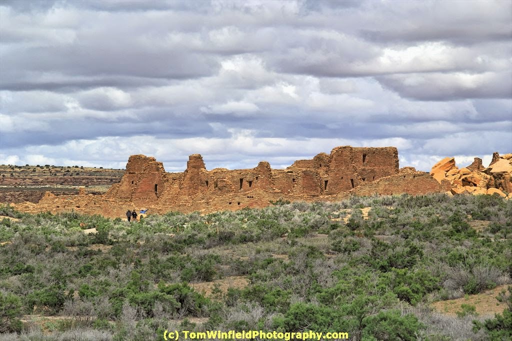
This recent trip, I was able to visit the Chaco Culture National Historical Park in NW New Mexico.  From books I picked up at the Park, the Chaco Canyon area was inhabited in the years 850 to 1150 CE. (upper photo)  Previous to this time, most of the inhabitants of the area were nomadic tribes.

During that same trip, I visited Aztec Ruins National Monument in Aztec, NM.   The Four-Corners area of the USA has many more ruins in what is called the San Juan Basin.  It is believed that various settlements in the area where located and moved as climate conditions change.

One of the more interesting parks is Bandelier, with their multi-room masonry buildings and cliff dwellings.  All of these settlements had one common factor.  The spiritual lives and rituals were centered around the kiva.  Many of these settlements had several small kivas and one large kiva.

With the influx of the Spanish Missionaries in the 17th century, the spiritual lives of the native peoples was changed by the Missions.  Most of these seem to be in the Rio Grande valley.  Undoubtedly, the El Camino Real Historic Trail was a large influence on the creations of missions in the area.

The spiritual center of the pueblo now was the mission church.  Life centered around the church.  The lower photo is of the Quarai Pueblo Mission.  Some of these missions were built on top of the ruins of the earlier settlements.

What is interesting to me is the similarity of construction of their building from the earlier days of the 1100s to later years to the 17th century.  Visit National Parks and Monuments to learn all about the early residents of the country.

Aztec Ruins National Monument
Bandelier National  Monument
Chaco Culture National Historical Park
El Camino Real Historic Trail
El Morro National Monument
Pecos National Historical Park
Salinas Pueblo Missions National Monument

There are more sites in New Mexico.  These are those that I have visited and took some photos.  Check out my web site for photos:  http://tomwinfield.com/new-mexico/albuquerque-nm.html


Sunday, May 10, 2015

Chaco Culture National Historical Park

Saturday was my day to move from Farmington to Albuquerque.  I have do say, I was not impressed with the town of Farmington, NM.

Under 200 mile drive scheduled for the day, so had time for some tourist activities.  Drove over to Chaco.  First, I have to admit that I was confused, thinking Chaco Culture was the same Canyon de Chelly National Monument.

With the weather conditions (threatening rain) and having 2 bicycles on a read rack, I was concerned about driving the unpaved section of the road.  A sign just after getting off US550 suggested to check road conditions by turned to the radio at 1610.  Well, there was nothing on the air at that frequency.  Road was mostly good, except for a couple sections which were very muddy.  I ended up some heavy, caked-on mud on the bikes.

After the 21 mile drive into the park, I stopped at the Visitor's Center.  Picked up my vehicle pass and a book about the area.  Drove the one-way loop road stopping along the way to take photos.  With the altitude and my knee, did not want ot walk too much.  Took time to walk up to Pueblo del Arroyo.  Most of my photos are of those ruins.

Back on US550, the next place I wanted to find was the ghost town of Cabezon. Had some snow in the air at Cuba, NM.  Found the road off US550 that I needed to take.

I passed San Luis and consulted the book, finding to get to Cabezon, I would need to drive some dirt road and could only be viewed from the mesa because of a locked gate into the town.  Passed on that, and back to San Luis.  Photographed the little church and several abandoned buildings.  Maybe will get back to Cabezon when weather conditions were more conducive.

While in this part of the state, I wanted to find the "White Mesa" mountain bike trails.  I was able to find the road off US550, just South of San Ysidro.  Did not have direction handy.  Driving on the gravel road, I thought I had driven enough and so not further signed except just off the highway.  Guess I did not drive far enough.  The web site says the bike trails are 4.4 miles from US550.  Another time.

Checked into the hotel and sent message to my cousin.  We met to Billy's Long Bar for a couple pints and a sandwich.  At the server's suggestion, I had the Roswell Ale.  Pretty good amber-colored ale brewed in Roswell (yes, the home of the aliens), NM

Monday, May 4, 2015

Manitou Springs. CO


I am on the road again.  Just over 600 miles yesterday from home to Manitou Springs, Colorado.

Was a stormy night at home Saturday.  That, and the normal problems sleeping before a trip, made it a long night.  There was a little rain in the air as I finished packing the car. Got on the road 3"45am CDT.  Stopped in Council Bluffs to gas the car.

The upper photo was taken along I-80 around Wood River.  The sky was getting light and the full moon was setting.  Did not get the focus quite right.

Stopped in Kearney for breakfast.  At Elm Creek, I dropped off the Interstate for the more "scenic" drive on 2-lane roads.  I have driven a couple times this route.  I just enjoyed the drive.  The weather has cleared and temperature climbed to 79 degrees.

I found some more old, abandoned buildings on the route.  These little towns of the plains have a treasure trove to photograph.  Got off the main road in Jennings, KS.  During scooping on block, I shot several good shots.

Another boring drive on I-70 from Colby, KS to Limon, CO.  I still J-76 from the Nebraska boarder to Denver is still worse.

Not much to see along US 24 from Limon to Colorado Springs. Saw several abandoned buildings like the lower photo. here.  I had to pay close attention as I neared the Springs. Route 24 takes a rather circuitous route..  It did not help there was a traffic jam near the I-25 interchange - sign indicated they were cleaning up a vehicle fire.

Found my Motel in Manitou Springs.  Had a problem with the room, I could not get a good internet connection. Interference with WI-FI from another motel.  Move from a room with a King bed to a room with 2 Queens.  The internet connection for more was more important than the size of the bed.

Headed a mile or so up the road to find beer and food.  The hotel desk clerk had suggested The Keg.  I was in heaven when a pint of Mass Transit Amber Ale was placed in from of me. The brew was crafted by Bristol Brewing in Colorado Springs.  There were a couple of problems.

First, I had not seen any parking meters.  Another customer told me where to pay parking - as the police in Manitou Springs love their parking fines.  Took care of that, but the place was only serving a limited menu because of a kitchen fire in March.  No fried food (could not have my burger).  I settle on for the french dip.  Had a second pint to wash it down,

The town of Manitou Springs looked like an interesting place to shoot photos and wander around,  but, I was just too tired and had left the D-SLR in the room.  i headed back to the room and crashed into bed.

Wednesday, February 11, 2015

On The Way Home

Tuesday I started having some mouth pain - upper corner.  Feeling light it might be starting of needing a root canal.  Had a rough night in the room in Albuquerque.  Early on the road y\towards home.  Called my denstists\'s office when they opened.  The will squeeze me in Friday morning.

Weather turning bad as I drove Northwest on I-25.  From Glorieta pass until Trinidad, CO,  I drove through periods of snow,  Thankfully, it has been warm the last week so it was not sticking on the highway.

By the time I was near La Junta, the sun was shinning.  Had a couple of "tylonol" to east my tooth ache (which had turned into a headache).  Bough a new bottle of the store=brand pain relief.  Took another couple pills.  Checked into my room in Oakley, KS.  Not up to eating dinner, just crashed into bed. 

Nothing much to see along the highway on this route.  Stopped a couple times to take photos of old, abandoned buildings. 

Friday, January 30, 2015

Mohave National Preserve

I was hoping to wear shorts for driving today, but it was just too chilly in Cedar City, UT.  When I went into the breakfast room, the coffee was not ready and the waffle iron was still heating up.  Finished putting my stiff into the car,  Had some breakfast and was on the road.

It was a chilly 38 degrees when I left Cedar City, just bit cool for wearing shorts. Opted for jeans.  By the time I was to St. George, the temperature in the 50s.  Topped off the gas tank in at the Nevada/California state line.  It was the most expensive gas - $2.899!

Dropped off the interstate and drove in the Mohave National Preserve.  About 20 years ago I was in the preserve at Kelso, CA for locomotive radio interference.  Wanted to check out changes in the area.  Wanted to see if the Cima store was still there.  While working in Kelso, heard the the depot was going to be restored.

The section of the preserve I was driving through getting to Cima if loaded with Joshua Trees,The Cima Store is boarded up.  The old Kelso Depot is now a beautifully restored building, serving as the preserve visitor center.  .Heading South towards Palm Springs I saw a sign to Kelso Dunes.  There's a large sand dune in the middle of the preserve.

It was a lonely, boring drive on 2-lane roads getting to 29 Palms.  There was no state visitor center at the California state line where I could pick up a highway map.  I used the National Park Service newspapers for Mohave National Preserve and Joshua Tree National Park.

Ran across a section historic Route 66.  As I got near 29 Palms, I drove through an area called the Wonder Valley.  About only thing out here was sand, scrub, and a few buildings (most abandoned).  Abondoned buildings  (think they might be called houses, but very small) continued populating the landscape as I entered 29 Palms.  I believe that 29 Palms is still an active Marine base, but the area his seen better days.

Was thinking of scoping out Joshua Tree National Park on the way to my hotel in Palm Springs.  By the time i was in the area,  I was just find my hotel and settle in.  Checked in the hotel and moves some stuff into the room.

Palm Springs has a free trolly that runs past my hotel.  Took the trolley to Smokin' Burgers and Lounge.  Had a cheeseburger and 2 pints of Firestone Pale Ale.  The food and brew hit the spot.  The bartender was did not seem friendly.  He acted that he was too busy to talk with his customers, except the little needed to do the job.

Back at the room, i started processing photos, but bed was calling.  Got up in the middle of the night finished that task and wrote this blog entry.  Some of my dinner came back up.  No idea if it was too much food, the 2 pints was too much or (most likely) something on the burger did not agree with my stomach.  Once I was over , I was feeling fine.

Photos with this posting are of Joshua Trees in the Mohave and the restored Kelso Depot.