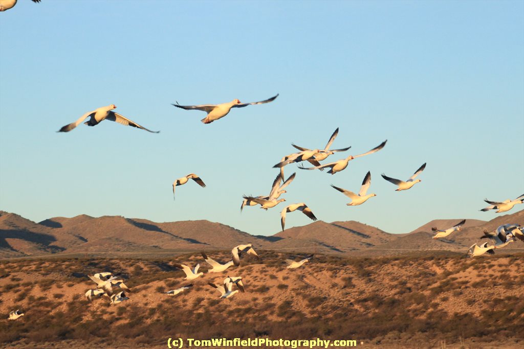
 Early rise and out of the motel to hopefully catch the morning flight of birds. I was driving NM 1 out of San Antonio. There were a lot of photographers just into the refuge. I stopped and took many frames of the snow geese as they leave the pond for their food spots. It was a chilly morning (about 18 degrees) but there where a lot of birders out. As the flocks dwindled I head over to drive the refuge roads. There were more snow geese at the South end where I photographed some a previous visits. On the North loop were many sand hill cranes. Was able to get close enough to get a couple good photos. Also go some great shots of other geese. Was a productive photo shoot.
Showing posts with label wildlife. Show all posts
Showing posts with label wildlife. Show all posts
Wednesday, February 1, 2017
Bosque del Apache
Early rise and out of the motel to hopefully catch the morning flight of birds. I was driving NM 1 out of San Antonio. There were a lot of photographers just into the refuge. I stopped and took many frames of the snow geese as they leave the pond for their food spots. It was a chilly morning (about 18 degrees) but there where a lot of birders out. As the flocks dwindled I head over to drive the refuge roads. There were more snow geese at the South end where I photographed some a previous visits. On the North loop were many sand hill cranes. Was able to get close enough to get a couple good photos. Also go some great shots of other geese. Was a productive photo shoot.
Monday, January 30, 2017
Quebradas Back Country Byway
 It was time to make a trip to Bosque del Apache. I decided to make a couple day trip out of it and
 play tourist. On the NM DOT web site I found map and information for some scenic drives. It has been dry, so I was sure back country dirt/gravel roads would be passable. Guebradas Byway was along my way from Rio Rancho to Bosque del Apache.
Thanks to good direction on the DOT web sire, I was able to find the byway off I-25 at Escondida (just North of Socorro). Follow carefully the NMDOT web site direction to find the start of this back country byway.
It was a welcome break from the Interstate and the traffic of the ABQ Merto area. Other than some folks out for 4-wheeling in "dune buggy type" vehicles, I only encountered about 3 or 4 vehicles on the 24 mile road.
The road drops you onto US380 about 11 miles East of San Antonio.From there, I drove south on NM 1 to the Bosque del Apache National Wildlife Refuse visitors center. By that time I needed was facility break and picked up pass for the refuge.
Tuesday, September 1, 2015
Day in Decorah

Did good selecting my lodging - just 2 blocks down the street to the Trout Run Trail. Started riding clockwise, riding as far as the fish hatchery, just short of milepost 5. Took me just past where the Decorah eagles are nesting. This section of the trail is pretty level and easy. Another mile and the hills start. Not ready for heavy climbing so turned back to my starting point.
When I got back, i still had legs left and feeling good. rode further almost to milepost 1. At this point, the trail is down between the levee and the river. Decided to turn around and get back to the motel. Good timing. I was getting tired and did not bring water/Gatorade with me. Stopped at the convenience store at the highway and started refreshing my electrolytes. The last 2 block gentle climb to the car was rough. Bike computer was not registering, so not sure just how fat I rode. Guessing it at 7-8 miles.
Stowed the bike in the room, started processing photos from the ride. Second shower of the morning and crashed on the bed.
Afternoon was for playing "tourist". Drove to the fish hatchery. Put the big lens on my camera, so it I could find the eagle nest, I am pretty sure I was successful (see lower photo).
 From there, i was scouting the trail - wondering if i should try riding other sections tomorrow morning. On to the North side of town to check out the waterfall in Dunning's Spring Park. Beautiful place. Back to the room to process photos for afternoon nap before dinner.
At the convenience store just down from the motel, the suggested food at the Stone Hearth Inn (next door to my motel). I was thinking of eating downtown at T Bock's Sports Bar & Grill. Both had local beers on tap. Stone Hearth being next door to the motel won the day.
Had a pint of Toppling Goliath Tsunami American Pale Ale. It was the best of the local beers for the area. Chowed down with an Iowa breaded port tenderloin (the kind the is about 3 times the bun size). Topped off dinner with ice cream with chocolate syrup.
Friday, August 1, 2014
Another Visit to the Zoo - Roof Repairs Stalled

Was a little bit humid and overcast when I stuck my head out of the door. I had already dressed in shorts and polo shirt, so decided is was a "Zoo" day.
Arrived at the zoo as the gates were opening. Got a good, close-in parking spot. The goal today was to get down to the petting zoo area. Did a detour through the Desert Dome - since most of it was closed when I was in March.
I get busy shooting photos, I do not get the names of most of the animals/ Another visit to the zoo, I should stop to shoot the exhibit sign so that I can later match the animal to the photo.
Stopped to shoot some flower photos. Most of the plants are NOT labeled on the zoo grounds. That would be helpful. For now, som eof my flora/florist friends generally supply the names after I post them on facebook.
All around of Bear Canyon I found these strange cheracters (see photo(. From the name, I think it was some Asian sculpture. (should have grabbed a photo of the sign). No idea it this is a semi-permanent exhibit.

The Zoo Railroad was running (I was sure sections of the track was torn up a month ago). Toured Bear Canyon, Lower photo is the American Black Bear. Got a couple shots of a peacock showing off his plumes. Peahens and chicks wandering the area around Sue's Carousal.
My 11am. my legs had enough. Splurged (50 cents) to ride the tram up neat to the zoo entrance. While it was overcast and not hot, I was sweating from the humidity. Treated myself to a Blizzard on the way home.
When I got home, I found no roofers. Not surprised. Exchanged e-mails with the contractor's salesman. He came to the house to apologize. Guess the company has a new work scheduler - and not coordinating much with the salesman. Was hoping to get the crew to my house tomorrow. Well - that was blown out of the water later in the afternoon - the house the crew was working on needed a new roof deck in addition to the shingles - so would not be getting to me tomorrow.
He gave me more info about getting the broken window. Have someone to work on that tomorrow - after I am home from breakfast.
Thursday, January 30, 2014
Birds, a Fort, a Trail, and a Blow-out

I have stopped at Apache in January each of the 3 years. In 2012, I was treated to a flock of snow geese taking to flight in front of me. Nothing memorable during my visit last year (I had time to check out the VLA in the generally same area of New Mexico). This year, some of the birds were cooperative, again. Here, a Sandhill Crane flies nearly over me.
Next stop was Fort Craig National Historic Site. Fort Craig was an important frontier outpost during the Civil War period. Since it was left to vandals and the elements all that is left are well deteriorated ruins and earthen walls. The fort was one of 8 forts that guarded the roads of the Rio Grange Valley.
Ownership of the fort was transferred to the US Bureau of Land Management in 1981. BLM has done a great job of preserving the history of Ft. Craig with interpretive signs. There is a small Visitor Center - staffed by a volunteer and open Thursday through Monday.
When I stopped at Fort Craig Saturday, on my way to Albuquerque, the host suggested I visit the El Camino Real International Heritage Center. The El Camino Real de Tierra Adentro - the Royal Road the Interior Lands - brought the first settlers to the area we now know as New Mexico. Center has exhibits and artifacts providing information about the history of this important historic trail.
By this time, we were ready to head back to Albuquerque. Stopped at a all-in-one "truck stop) for G2 - needed hydration. Tooling up I-25 about 40 miles South of Albuquerque at 65mph, my car suffered a tire blow-out. Not just a flat, but the tire sidewalls were in shreds. Will have to get a new tire tomorrow morning.
Sunday, January 26, 2014
"Ghost" Towns

Late start. Tt was almost 11 by the time we said our "good-bye"s, I gassed the car, and headed up the road. First destination was the "ghost towns" of Hillsboro and Kingston, NM.
I say "ghost town" in quotes as these tows are not ghost towns as depicted in TV westerns. The population of these towns have waxed and waned as the economies of the area changed. Both of these towns have an eclectic mixture of ruins, abandoned buildings, run-down shacks, well preserved structures and new construction.
Made a cursory tour down Main St of Hillsboro, snapping a couple photos. Continued on to Kingston. Most impressive structure in Kingston is Black Range Lodge. The lodge is a Bed & Breakfast as well as a retreat center. Interesting place in south-central New Mexico.
A couple photos in Kingston and back to Hillsboro. By this time,I was looking for a rest room and some a sandwich. Decided at the General Store & Cafe. Ordered a burger and went to the rest room. What a "treat"!. the "WC" was about the size of an airplane facility or less. Hand holds on the dorr jamb to help sit. The lower photo is part of the interior of the Hillsboro General Store Cafe.

Spent some time shooting in Hillsboro. Soon, it was past time to be on the road North toward Albuquerque. As I drove, I thought I might swing by Bosque del Apache National Wildlife Refuge to see what are currently in "residence".
When I exited I-25, as I turned North the signs included information for El Camino Real International Heritage Center, Apache, and Fort Craig. Hmm - Fort Craig, had not heard about this fort. Drove the 4.5 miles on gravel to check it out. Visited with the host there about the ruins of the old fort. It was already after 4pm, was too late and my legs were not up to doing a mile hike to explore the fort.
The host at Fort Craig said the El Camino Real Center is worth a visit. Maybe one day this week while in Albuquerque, can make a day trip to the center, fort, and refuge.
Rolled into my motel just after 6pm. unloaded much of of my stuff out of the car into the room. Still have to bring the bikes into the room. Contacted my cousing here in Albuquerque to make tentative plans to getting together while my stay.
Wednesday, August 28, 2013
North Loop of Yellowstone

Walked some at one of the pools and another walk at Gibbons Falls. Legs and knee were doing pretty good. (Not 100%, but pretty good). I took it easy as I had a long day ahead yet.
At Norris Geyser Basin - the walk was almost too much for me. Wanted to get some good photos. Did NOT walk down to the bottom of the basin. But it was an effort to get back to the car. Didn't help that I left my walking stick in the car.
By the time I arrived Mammoth Hot Springs, I was getting hungry. Stopped at the Terrace Grill (fast food). Needed some nourishment and coffee. Back up to the Springs. Drove the upper loop and did a short walk.
There was road construction in the Tower Falls area. Almost passed on stopping there because the lot was full. But, someone left, and I parked. Started leaving the parking lot when remembered I forgot my walking stick. Grabbed that and headed the path to the falls. Only walked to the upper viewing deck. That was enough by the time I got the the gift shop. Did a little shopping and headed back on the road towards W. Yellowstone.
Drove the one-way road past Virginia Cascades -- not a good view angle form the road (without walking down the road a bit). My legs would not handle that.
Back in West Yellowstone, I did some more shopping, early dinner at the Outpost Restaurant. From there, Gas up the car and stop in the grocery store for sports drinks. Finally, back in my motel. Body is exhausted and my legs are sore.
Got my photos processed. Today's photo is of a moose (or were they elk?) family in Madison River. Now off to bed!
Tuesday, February 19, 2013
Eagles at Manawa

Sunday John brought a print we took at coffee. After coffee, I headed to Manawa to find the eagle. John had seen them in the area of Boy Scout Island and E. Manawa Drive.
I started on the West side where I visited with Tom. No eagles. Next stop was Boy Scout Island. A few geese, and some large birds further into the lake. Took a couple photos but was getting discouraged.
Looked there were a group of folks stopping along the East side of the lake. Drove there and parked along the road as there were several large birds flying in the area.
I forgot how difficult it is to fallow birds in flight and keep the lens in focus. Auto focus was having a fit. Switched to manual focus (which I am not accustomed to - like how to move rings to focus vs zoom). Was able to a get a couple "in flight" photos.
One immature bald eagle decided to perch on a branch right over my car. Gave me some time to fine tune the focus. Here's the best of the photos I took.
Liesurely Ride on the Lake Manawa Trail

A little remiss blogging about my ride last week. Wednesday was about the only day that was warm enough and not windy, conducive for a bike ride. Aired up the tires on the hybrid and loaded the bike to the car rack.
A chilly breeze was blowing from the SW. Temperature did not feel the 50 degrees that the thermometer indicated. Headed down the Lake Manawa Trail and see how far I decided to ride. A little before I reached the Indian Creek bridge, I ran across "Tom" - a bird watcher & photographer. We had stopped and visited previous (at almost the same place on the trail).
Tom told me he was planning to shoot some photos of the eagles that are now calling Lake Manawa State Park home. That peaked my interest. Continues my ride to the bridge and turned back towards the trailhead.
In no special hurry, when I caught up with Tom again, I rode with him (he's on foot). He's still shooting film (slides) with a Canon EOS. Planning to get some photos along the E side on Lake Manawa. Made plans the meet with him after I finish my ride.
Decided to take a little side ride on the Nature trail. (see photo). Noticed several large bird nests high in the trees along the nature trail. Pedaled on to the car and loaded the bike on the rack.
Thought I might have missed Tom since it took a little longer for me to get back to the car and load the bike. Thought I might have missed him, but found him at the place expected. Watch the eagles and visited a little. Gave him one of my calendars.
Didn't ride many miles but sure had a enjoyable afternoon. Topped it off with a visit with Blaine at the bike shop.
Thursday, January 31, 2013
Wildlife and the Cosmos

Monday was cold, Tuesday was windy. Took the opportunity to get some rest and recover. Yesterday, I was ready to get out and do something. Once it warmed up enough, I headed south to revisit Bosque del Apache National Wildlife Refuge. Figured that if I had time, I might check out Very Large Array while in te area.
I was disappointed with the wildlife out yesterday. No snow geese - guess they had headed North already. Did not see any deer. Lots of cranes and ducks. Took a couple photos and headed to VLA.
Very Large Array is a collection of 27 antennas configured in a "Y", comprising a radio telescope. Each dish (antenna) measures 82 feet across. When set in the widest configuration, the array acts as one dish 22 miles in diameter!
You will find the Very Large Array in the Plains of San Agustin 50 miles West if Socorro, New Mexico. Interesting day.
Friday, February 3, 2012
Bosque del Apache NWR

When i stuck my head out of the hotel room this morning, it was cool, overcast, and looked like it had snowed! I knew that the storm was going NE, and checking weather.com, it seemed to be a nice day to go South the the Bosque del Apache National Wildlife Refuse.
The refuge in about 100 miles from Albuquerque. Exit 139 on I-25. Go east about a hald mile to the flashing yellow lite (Old Highway 1) at San Antonio, NM. Right (South) 9 miles to the refuge.
Now I am not a birder, and photographing birds surely has not been my strong suit. Might as well try it. What better place than the refuge - with all of the migratory birds!
I stopped at the Visitor's center for my pass and visit with the staff. Talking with they lets me tell them what my goal is. They then gave me some suggestions to enhance my experience at the refuge.
Started with the Marsh Loop. The first large flock of birds I saw were the Snow Geese - just as I turned when the road turns one-way. Think I startled them - because most flow off a little further from the road.
Just past the Snow Geese, I walked partway down the John Taylor Memorial Trail. I did not make it to the end (where it looks like there was a blind there). My legs were not willing.
Not going to bore you with all of the details and lots if photos. After all, its a learning shoot for me! I had my telephoto zoom lens, I could get some pretty good shot. The problem was when i wanted to follow a bird 9or a flock) to get the bird in focus. When i get homw on the larger monitor, i will be able to see how good 9or bad) I did.
Continuing on the Loop Road, at the cross connector, I was on the Farm Loop. At the North of the Farm loop I found the cranes. Almost done, I stopped at the Flight Deck.

I did not bring my bicycle on the excursion. There was some comment on the web site that the Loop Road was closed to bicycles from Oct through April. Bicycles could ride the East Low Flow Conveyance Service Road. The volunteer at the Visitor's Center told me that studies showed that bicycles scared the birds. Walkers and cars do not bother them, but bicycles cause problems.
Back into San Antonio, it was a little after 1 and i was getting hungry. Stopped into the Owl Bar and Cafe for one of their "world famous hamburgers". I did not have one of theor burgers - opted for the patty melt. North back toward Albuquerque.
Stopped into Socorro for gas. As i recalled, there was some mountain bike trails around Socorro. Found the Chambers Tourist office. No trail maps, but was able to refer me to a local groups - Socorro Striders and Riders. Will have to check it out for my next trip South from Albuquerque.
The busy day was topped off with a couple beers with my cousin and a friend of his. Planning to sleep in!
Subscribe to:
Posts (Atom)
