Thursday, June 30, 2011

Busy Week


This week I am visiting Kenosha. While there, I was able to visit with a high school friend that I had not seen in many, many years. Was good to reconnect.

Have been visiting my mom. Yesterday I was out on the bike for a ride. Rode from her apartment North into Racine. When I got done, just over 15 mile ride. Took a few photos that my show up on a future calendar.

Later this morning, I am planning to ride the Kenosha lake shore.

Have not blogging much, because there is no internet in the apartment. First thing in the morning I drive to Panera Bread to check my e-mail, facebook, etc. Suffering a bit from withdrawal.

Tuesday, June 28, 2011

Iron Skillet Rip-off

Yesterday was my traveling day. Loaded up the car and headed from the Quad Cities to Kenosha, WI. Wanted to get an hour or so under my belt before breakfast. Gassed up the car and headed on the highway.

Plan was to eat at Rochelle, IL. Pulled into the Petco Travel Center. Wanted to get out of the car and do some computer work at breakfast. Got my coffee and water and started studying the menu.

To use the wi-fi, I would have to sign up for an account and pay $1.99 for an hour use. Bullpucky! I just had my breakfast and stopped by the cashier. Told her that this was ridiculous - I was spending $11.00 for breakfast (normal eggs, potatoes, meat, toast and coffee) and would have to PAY to use the internet!

She game me the phone number for Iron Skillet Customer Service. Told here I was planning to blog about my complaint. Damn - with $11 breakfast and a truck stop/travel center, they should PAY ME to use the internet.

When I was in northern Wisconsin - lots of little bar and grills in out of the nowhere had free wi-fi for their customers!

Anyway - I am black-listing Iron Skillet restaurants. Hope you do, too.

Sunday, June 26, 2011

I LOVE to Explore on My Bike


After a rainy afternoon and evening yesterday, today dawned sunny. Headed to the Park for breakfast - had breakfast pizza. From there to the HQ area of the park. When I got there, I found that aliens were riding our bikes. Spending the time riding the skills obstacles. (See first photo).

Was a relaxing morning visiting as waiting some away rides left for ride venues. Said my "good-byes" and headed to the motel. Day to explore paved trails in the Quad Cities.

Parked downtown Davenport at the Visitor's Center. They had a great bicycle map of the Quad Cities. From there, rode South along the Mississippi Iowa Riverfront Trail. Rode until that trail ended at Credit Island Park. Back North the trail until it ended at Isle Casino in Bettendorf.

The wind today was coming down the river. Had a easy ride with the wind back to the car.

When I got back to the car, I had just over 13 miles. A good ride, but the day was just too nice. It was ordering me over to the Illinois side of the river to continue exploring.

After some fits and starts to find a trailhead, I found Schweibert Riverfronk Park. Parking spaces and the Great River Trail runs through the park. Awesome!

Checking the map, I set off North the Great River Trail to Sylvan Island. Wantehttp://www.blogger.com/img/blank.gifd to find out what this island had to offer (since there were "away" ride there during the festival. Found a network of dirt and crushed stone trails.

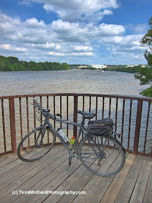
Rode around the island on my hybrid. Snapped the lower photo of the bike on a river overlook on the island. Stopped and visited with a family that had recently moved back to the Quad Cities from Medford, OR. Guess the economy is in the pits there.

Still not ready to turn back and call it a ride. Rode on North to the Convention Center. Time to ride the wind back to the car. Great 21+ miles ride and over 2 1/2 hours exploring by bicycle. And, I rode in all four of the Quad Cities today!

Finished up the awesome day with a meal at Thunder Bay Grill - just across US 61 from my motel. Settled into a comfy chair. Started with water and a glass of Iowa Pale Ale. Asked the waiter that i wanted to relax and process the photos before ordering. That done, ordered a burger and fries and started this blog posting. Nearly perfect timing - about to finish the post when my food arrived.

Great ending to the day. Packing up and heading to Kenosha in the morning.

Saturday, June 25, 2011

Midwest Mountain Bike Festival - Day 2


It was a busy day at the festival. It started off with a pancake breakfast by the Eldridge Lions which was held at the Sac Fox campground shelter. From there is was over to the main festival area.

Group rides were organized. The kid's ride headed out. At that time, I decided it was time for me to ride. My goal was to ride the other loop (Parkview Loop). Carol (FORC member) recommended to also ride the Pine Bowl that comes off of the Parkview Loop.

The Parkview Loop is a little longer, and sections of the trail has tighter clearances and sharper turns. Then again, there are some longer straight-a-ways. The loop is a green trail (as was Long Grove Loop I rode yesterday).

Pine Bowl is a blue trail, yet I found it easier than sections of the Parkview Loop. Did not have the tight turns.

All-in-all, by the time I was getting near done the Parkview Loop, I was tired. Could see/feel I was losing the control of my bike. No crashes - thankfully. After the ride and a sandwich, I decided to head to the room for stretch my legs and maybe take a nap.

After the rest, it was time for the "Not Lame Games". First was "Huffy Toss". The goal was to see who to throw a "Huffy" bike the furthest. The other game was "Bicycle Dodgeball". Riding bicycles, throwing bicycle tires at the opponent in a classic game of dodgeball.

During the games there was a constant drizzle - making the grass very slick. It was also getting cool and damp. I decided I had enough for the day - skipping the potluck BBQ and the beer potluck.

Raining very hard on my drive back to the room. May have to grab the hybrid tomorrow to ride pavement.

Today's photo shows my Fuel EX7 on the Parkview Loop.

Friday, June 24, 2011

Midwest Mountain Bike Festival - Day 1


Was a looong day today. As usual, I could not get to sleep last night - before trip restless. Gave up on sleeping about 3:30 in the morning.

Went into packing the car (as usual - packing 3 times what I need). Normal chat. Then headed into Council Bluffs to gas up the car, pick up a couple groceries for the trip, and lubed the car. Was out of CB before 8am.

Had to stop for coffee and breakfast (getting tired). That gave me the rush to drive on. Stopped in Iowa City for a break. Eventually arrive in Quad Cities 3pm. Checked into the motel and then found Scott County Park for registration.

Back to the motel to change clothes for a bike ride. At the Trek Demo Trailer, it was like "old home weekend". There was Ryan Schutz IMBA Director of Field Programs, Morgan & Steve Lommele of IMBA Trail Care Crew, Hansi Johnson - IMBA Midwest Regional Director, Trek Rep from Des Moines (sorry, have forgotten your name) and Ken Derrico - Midwest Factory Demo Rep.

I was offered to ride with the group. I decided to ride myself to check out the trail (if I can ride it without major difficulties) and I did not want to slow them down. Rode the Long Grove loop (about 2 miles). Almost all of the trail was within my riding abilities. Stopped to walk a couple bridges and walked once to slow down my heart rate (got it up to 120 bpm).

Bed time now - need my rest. BTW, today's photo was taken on the Long Grove Loop, Scott County Park, Eldridge, IA

Tuesday, June 21, 2011

Flooding Overview


Yesterday I got up to Lewis & Clark Monument to view the flooding from that vantage point. In the middle of a Monday morning, there were not too may folks up there. The view sure illustrates the extent of the flooding.

I am trying to find a photo I have of Big Lake in its normal state. The river has swallowed the lake. You can see I-29 disappearing into the water. On the way back into town, I was going to take photos of the flood waters under the railroad trestle. Lots of "No Parking" signs there. Guess I will ride the bike one day up there for the photos.

National Guard troops are paroling the levee. I sure hope the levees hold. The river is expected to be this high until well into August. Don't think levees were expected to hold the river that long.

Riding the Trace


With all the flooding along the Missouri River, bicycle riding has taken a turn. The longest ride on paved trails in Council Bluffs is Valley View, 5 miles one way. The options are riding the streets and roads or riding the Wabash Trace.

Over the last week, I took two rides on the Trace from Silver City to Malvern. I was surprised to see the Silver Creek is quite low. Might be a bit higher now, with the rain this week. Some change from the Missouri!

Friday's ride was solo. Took a few more photos of the Silver Creek Bridge. Trail surface was pretty good, just a couple soft spots.

Sunday, I rode with Dennis. With the rain Saturday night, the trail was a little soft. Slowed me down some. We headed out from Silver City about 10:30 as it was going to be a warm and humid day. Though there was a breeze from the SE, there was basically no air moving on The Trace. We were both dripping with sweat when we got done about 12:30. I stayed inside the rest of the day (computer work).

Lots of traffic on the Wabash Trace Sunday. More than I have ever seen before between Silver City and Malvern. Does the flooding (closed trails along the river) put more traffic on the Trace? Sure seemed to, Dennis and I both expect to ride the Trace more this year because of the flooding.

Thursday, June 16, 2011

Home and Flood Report

Monday I drove home from Deerwood, MN. Had a good time at the Cuyuna Lakes Mountain Bike Festival. Talked with one of the organizers, commented on a couple things I liked and did not like about the festival. She said they are planning to send out a survey (which I had recommended). Uneventful drive home - just tired. Still was able to pick up the mail and stop by the bike shop to check on my road bike.

Tuesday, I just could not get out of bed. Over slept and missed breakfast. Did got out and about in time for my doctor appointment (physical). No problems other the aches and pains from the crash and age. Picked up the road bike (was in for its first annual inspection and tune-up). Rest of the day - crashed.

Wednesday I just had to get out on the bike, even though I was a bit tired. Parked at Lake Manawa (at the nature walk). Plans were to survey the trails so see how far I can ride. Here's What I have found, so far.


Heading toward the Wabash Trace - Mosquito Creek is flooding the trail under the railroad.


Construction of the new trail connecting Lake Manawa Trail to the Veteran's Memorial Trail (East side of Lake Manawa).


Missouri River Boat Ramp Parking Lot - and our mountain bike trails).


Bridge over Indian Creek - Note the people on the far end of the bridge. That's National Guard patrolling the levee. Officials do not want the public on the levee, at all.


Indian Creek under Highway 92.


Veteran's Memorial Trail at S. 24th St.


Iowa Riverfront trail behind the Western Historic Trails Center.

Sunday, June 12, 2011

Circumnavigated Portsmouth Mine Lake


Needed a good breakfast this morning. In our festival packets there was a slip of paper about a local youth center breakfast. Alas, there was no information of where the center is. At the motel, they said it was the Hallett Community Center - it wasn't. So, I parked on Main St. Crosby and ate at the North Country Cafe (where I ate last evening). And knew they had good food.

Day 2 of the Cuyuna Lakes Mountain Bike Festival started with a demo/workshop with Hans Rey. The workshop was held in the "skills" area (also know as Timber Shaft Trail) of the Yawkey Unit.

This was not a demonstration of jumping tables, and such. It was just some awesome riding on extremely technical trails. Hans coached the other riders, how to ride the technical features. The trail they were riding was basically rocks and technical features. At times it was difficult to see where the trail was.

No way I could ride that trail. But Hans "No Way" Rey made it easy.

OK, not time for some riding of my own. After changing into my cycling kit, I headed to the Crosby park to figure out where I could ride. Trails in a large section of the recreation area where not available for open riding because of the cross country race.

It was suggested that I ride some some of the blue (yellow on the map) trails in the Yawkey Unit. Checked out the trails, but most of them were one-way. I did not want to commit to a loop and they had rollers that were a bit too much for me.. The trail back to town was 2-way, but had some steep drop-offs.

Next I drove over to "Boot Camp". The maps shows it is a "green" (easiest) trail. Looked at it, but again, drop-off was a little too much for me. Since yesterday I enjoyed Drag Line yesterday, decided to check it our from the other end.

The first third of the ride on Drag Line was good. Most of the trail I could ride. Would have felt better (and might have ridden that while section) if it was not my first riding the trail.

That quickly changed when I encountered the 1-way section of the trail. Steep climb (and then decent) with a drop-off. I knew that the other end of the trail had another section I could ride, so plugged on, with walking most of that third of the trail.

The last section of the trail was a piece of cake - I had riding it (two way) yesterday. Drag Line nearly follows the north shore of Portsmouth Mine Lake. The Cuyuna Lakes State Trail forms the South end of the lake. The paved trail was a treat after the singletrack. I think I have enough calender quality photos of Drag Line to hold me for several years.

After the ride, i stopped back at the park to pick up one of the bright green festival t-shirt and on to DQ for a Blizzard (I earned them).

Washed the orange dirt on the bike tires. Now time to start packing for the trip home.

Photos of the workshop with Hans Rey are on my photo web site. Copies of the photo file are available for purchase at http://win-photo.photoreflect.com.

Saturday, June 11, 2011

Cuyuna Lakes Mountain Bike Festival


Today was the opening day of the First Annual Cuyuna Lakes Mountain Bike Festival. I was at the city park at 9am for registration. They were still setting up. For those of us first in line, it was disorganized confusion. Like the ribbon cutting yesterday, it was difficult to find someone that could answer questions. Drove back to my motel to change clothes and bring the bike for the parade.

I thought the bike parade would just be a ride in town. With Hans Rey in the lead, we rode out of town to the Pennington Lake Parking Lot and scattered into the trails. Talked a little with a Minnesota Off-Road Cyclists (MORC) member. He suggested (as I was thinking) to start with East Street (since it was in the area).

Started that trail and quickly saw that the trail is cut into the hill, with steep drop-off. I did not feel comfortable riding this trail. Took a couple photos and headed back to see where else I could ride. Maybe Boot Camp which does not have so drop-off.

On my way back to the car riding the paved trail, I noticed some "Blue" singletrack off the pavement. Checked out the trail (which was named "Drag Line"). While the tread was more narrow, it was mostly flat and no sharp drop-offs. Rode this trail for a while (and took some more photos).

Back to the pavement, was gonna check out the other end of Drag Line. But, I was a bit tired and not feeling comfortable riding the trail. Back to the city park. Organizers suggested taking the grand tour (for $5). The tour included a pontoon boar ride and a tour of the Croft Mine.

The shuttle bus took me back to the Pennington Lake boat ramp. There were a large group waiting for the small boats. When it was 3 boardings and I still was not aboard, I gave up on the boat ride. That and the loud guys on the shuttle bus, I was about to shuck the whole tour.

Next stop on the tour was the Croft Mine. Got away from the big group and was able to walk a bit and take photos. Ended up melding back into the group for the mine shaft tour and my ride back to the park. Seems that my timing was awful - had decided to do the tour when the antique car group in town also decided to do the tour.

My mood was just a bit soured enough that I just wanted some food and back to my motel. Missing the Hans Rey riding demo, some extreme mountain biking films, and fireworks. Also, I had signed up for the night ride, but when I found the trail the ride will use, I passed.

Tomorrow is another day. Better to get a good night sleep rather than overdo things.

Friday, June 10, 2011

Ribbon Cutting and a Ride


This morning I attended the "ribbon cutting" for the new Cuyuna Lakes Ride Center. Because of threatening weather, the ceremony was moved into the Hallett Community Center in Crosby, MN.

A host of officials spoke during the ceremony, from the former Congressman (Jim Oberstar), State Legislator, Commissioner of Minnesota DNR and staff, local politial leaders, local Chamber of Commerce, Mike Van Abel (Executive Director of IMBA) to others in the mountain bike community. Cuyuna Lakes is a Bronze level IMBA Ride Center. There are 22 miles of singletrack in Cuyuna Lakes.

Other than Cuyuna Lakes Ride Center, I cannot find much information about the IMBA Ride Center program. In 2008, I first heard about the concept during Black Hills Fat Tire Festival. Now, Cuyuna Lakes is open and it appears the Oakridge Oregon Ride Center is threatened.

A local food vendor was offering box lunches for $6.00. Looked like a good amount of food, but I wanted some hot lunch. Stopped at Coaches' in Deerwood (very close to my motel). Good food.

Now, to get out to ride. To feel more comfortable, I decided to head out on the Cuyuna Lakes State Trail. This is a paved trail that connects Crosby, Ironton, and Riverton, MN. Today's photo is of the Cuyuna Lakes State Trail.

The Cuyuna Lakes Mountain Bike Festival actually gets underway in the morning.

Thursday, June 9, 2011

Cross the border to Minnesota


It was cold and windy this morning. And for some reason, I was a bit tired. Slow getting going and decided to not ride before leaving Superior. Went on across the river to Duluth, MN. Was going to find some bicycle trails to photograph. A singletrack trail looked promising (from the maps). I could not find the trailhead on Skyline Drive.

After taking some photos from the drive (overlooking the twin ports), I stopped in the Minnesota Information Center. They recommended a stop at Jay Cooke State Park.

Stopped at the park office. Day permit is $5. Talked with the ranger there to see if I would need a sticker at the Cuyuna Country State Recreation Area. Since I will be there for 3 days, it made some sense to buy the $25 annual sticker. Anyway, unlike other states, the Minnesota sticker is valid for 12 months, not a calendar year.

Had a nice visit in the park. Near the park office is the Swinging Bridge over the St. Louis River. Got some good photos from the bridge. Also, per the ranger's recommendation, I drove about a miles to another parking lot. Walked a paved trail and was treated to a couple beautiful vista - overlooking the St. Louis River.

From there it was a boring and uneventful drive to Deerwood, MN. Checked into my motel.

More Waterfalls and a Museum


Wednesday was a short drive from Ashland to Superior, Wisconsin. Two State Parks was on the agenda - Amnicon Falls and Pattison. Both are near Superior.

Amnicon Falls State Park is along Highway 2, about a mile from Highway 53. All of the falls can be viewed with a short hike (the same of about walking around a city block).

Being Spring, I was treated to water falling over "On and Off Falls". In dry seasons, the falls is dry. Viewing that falls is just to right from the restrooms.

From there, head over towards the covered bridge. Before you get to the bridge, the main falls is on your left. If you want, you can walk down to a viewing platform and even on down to the river side. I did not to climb down (and back up) with my cameras.

Took some good photos from the bridge (top photo). Then continued my hike around the island. On the back on the island is another falls. Finally, the lower falls. The best view of the lower falls is down from the covered bridge, back on the mainland side of the bridge.

It was a little after noon, and I was getting hungry. At the US 2 and County U (road to the park) is Rapid's Riverside Bar & Grill. Had a good bacon cheeseburger and kettle chip. The place even had free Wi-Hi and i was able to check mail and facebook.

From there, county roads to Pattison State Park. Pattison is located on Highway 35 South of Superior. When I was planning this trip, I almost bypassed this park. Glad I did not miss it.

Manitou Falls is a "don't miss" falls. At 165 feet, It is the highest falls in Wisconsin and the 4th highest East if the Rockies. I parked near the park office. Walked past the beach, under the highway tunnel, and on the trail to the falls.

Hicked down the side of the river to the two viewing points. Saw others viewing the falls from the other side of the river. So, crossed the little bridge and hiked the other side.

It left me with a longer hike but saw the falls from both sides of the river. While exploring the park, I saw that I could have parked at another parking lot (on county B). Guess the exercise was good for me.

The best view of the falls is from the second viewing point on the small parking lot. When I got back to the car, I drove the mile down Highway 35 to find the Little Manitou Falls. It was worth the time - a pretty falls with lots of water dropping over the falls.

Found my motel. When I checked in, the told me there is a special at the Veteran's Museum in town. after checking in the room, I headed to the museum. The museum is named after Richard I Bong (whom was from Poplar, Wisconsin). Lots of stuff in Superior (and the state recreation area in Kenosha County - other corner of the state) is named for Bong. Major Richard I Bong was a WWII ace fighter pilot.

Tuesday, June 7, 2011

Ashland, Wisconsin


Ashland was a home of one of the big iron ore docks on Lake Superior. The remains of the dock dominates the lake shore. Unfortunately, the historic structure has been deemed unsafe and is scheduled for demolition. When I found out this, I was glad I took a bunch of photos of the dock while in Ashland.

From the dock, I headed to the Northern Great Lakes Visitor Center for more information about the area. That was a waste. When I told them I was looking for landscapes and seascapes to photograph. The started telling be about the yards of some of the old houses. At the motel, they suggested I drive up to Bayfield.

The folks at the information center there weren't much better. I ended up walking around the dock area a little. Then went up by the orchards where they said I would get a good view of the Apostle Islands. I could not. The only view I had was from the docks - of Madeline Island.

Back in Ashland about 1pm. Waiting for some more warmth before my bike ride, I headed to Main Street. Wanted to look at and photograph some of the old buildings. There, at least, I was successful. Saw, and photographed some of the murals painted on building sides.

Getting hungry, I was parked near Buddies Burgers - a 50s style diner. Another mistake I made today. They had a special 1/4# burger, fries, and medium soda for $6. I ordered a burger with pickle, onion, and lettuce - I got one with pickle, onion, and tomato. The fries were very dark, and soft/limp but at least hot. Fries were dripping with oil. And my "Medium" soda, I would had to see what a small looks like! I was not impressed. My recommendation - PASS on Buddies Burgers.

OK, lets try a bike ride - that has to be better. Kitted up and headed out from the motel to ride the Ashland Rail Trail - Waterfront Trail. Riding that trail gave me another and closer view of the old ore dock. The top photo in this posting was taken during my bike ride. The Ashland trail turns away from the shore and winds around and ends up to be the 5th Street Corridor. At Sanborn Avenue, the 5th Street Corridor turns into the Tri-County Corridor.

Took me some time to get comfortable and feel good riding again. Was a little apprehensive. By the end of my almost 9 miles ride, I was feeling better. But, damn it is rougher pedaling the fat, knobby tires than the skinnies.

Anyway, got a few good trail photos for the web site, blogs, and calendars.

Copper Fall State Park


Packed up the room yesterday morning. Took my time (still a bit sore). The first stop was Copper Falls State Park.

Spent about 2 hours at the park. Walked/hiked the Doughboys' Nature Trail. The trail makes a 1.7 mile loop in the park. The trail started off easy enough. A little over half way, there's a long stairway down to the river. Over course, on over the river, had to climb back up the stairs. That was the roughest part of the hike.

The scenery was great. Brownstone Falls (today's photo) is actually more impressive that Copper Falls. More photos will be posted on my web site (when I get into updating the site). I think I was at this park many years ago during a family vacation. Just the falls seem to be smaller that I remember (of course, I was much smaller then, too!)

the nature trail brings you to views of Copper Falls, Brownstone Falls, the Cascades, and Devil Gates. Copper Falls in on the main branch of Bad River. Brownstone Falls in on Tyler Forks Branch of the Bar River.

Copper Falls State Park was an effort by the Civilian Conservation Corps (CCC) and the federal Works Progress Administration (WPA). The park is located near the town of Mellen, WI and a 23 mile drive from Ashland.

Today's plans include a ride along the lakefront on the bike path and playing tourist here in Ashland.

Monday, June 6, 2011

IMBA Epic Tribute


Chequamegon Area Mountain Bike Association (CAMBA) Rock Lake Trail is now an "Epic" trail. The International Mountain Bike Association (IMBA) "Epic" designation was announced in November.

On June 4th (National Trails Day) CAMBA members, IMBA members, the US Forest Service, and Festival of the Trails participants gathered at Rock Lake Trailhead to pay tribute to the trail. The CAMBA Rock Lake Epic actually is a collection of interconnected trails in the Namakagon Cluster - Rock Lake, Patsy Lake, and Namakagon Trails.

After the tribute, some started off to ride the 31 miles of the new Epic. Another group rode some easier section of the trail.

The Rock Lake Epic and the other CAMBA trails are in NW Wisconsin. Eventually the area will have over 100 miles of interconnected trails around the area. Towns of Cable, Delta, Drummond, Hayward, Namakagon, and Seeley host the CAMBA trail system.

Check out the CAMBA web site for more information about the Rock Lake Epic, CAMBA trails, and Festival of the Trails.

Sunday, June 5, 2011

Why the new Cycling Camera


A short time ago, I reported that I had purchased a new Point & Shoot for use while cycling. Here's why.

The photo above is the standard photo taken by the new camera. Notice that the exposure of the trail tread is about right. Sections of the rear bike tire and the background in the distance are over exposed (blown). Yet the stump on the right side of the trail is barely visible.

A camera cannot capture the full dynamic range of the lighting in the photo. So, I set up the camera to take 3 bracketed exposures. One, is the normal exposure (photo above), one under exposed by 2EV (Exposure Value), and one over exposed by -2EV.

Those 3 exposures were combined by HDR Photo Pro. The result was a tone mapped photo representing the full dynamic range of the photo. (lower photo)

BTW, this photo was taken on the Patsy Lake Trail, one of the CAMBA trails.

Friday, June 3, 2011

Three Crashes - Ouch


Well, I started out the Festival of the Trails with a big bang. After getting registered and checking out where the punches will be located, I was ready to start riding.

Bill (whom rode with me first afternoon last year) arrived. Stopped to visit for a little. Then headed down the new trail which had the closest punch. A few yards dorn the trail I hit a large rock - ENDO! Took it easy and walked lost of that trail and eventually got my ticket punched.

Photo with this posting is a photo of the first trail I rode today. Pretty tame, eh. until the up/downs and rocks get thrown in.

After a walk back up the hill on the pavement, it was time to check up the trail being used for the night ride. Right away there was a good climb, more than I wanted ed to tackle in the dark.

Now, I wanted to accumulate some punches on my ticket. Checked out the gravel/dirt rode which comes close to some of the spots - Phipps Fire Lane. Found 3 punches without a lot of trouble. Only one light crash.

Things were going so well, I figured I would do one more ride to find a punch. Big error! I violated my own rule - never take that last run of the day. That's when you get hurt, when tired.

Could not find the punch I was looking for. Decided to turn back to the car. That's when I had my SECOND endo of the day. At it was a doozy - a full face plant into the sand.

A little sore when I got back to the room. Figured that was enough riding for the day. Cleaned up and had dinner (at the Angry Minnow). Now time to drive up to the Meet and Greet. Leaving my bike in the room!

Hayward Tourist


Just a quick post this morning. Did some errands (Wally World, Post Office) and played "tourist" in Hayward. Walked section of Main Street then went to the National Fresh Water Fishing Hall of Fame & Museum. Now, I am not big on fishing, bit the museum is on the "must see" list in Hayward.

So, this morning's photo is of the gigantic muskie at the museum.

Also sorted out room problems - moved into a different (larger) room. Now getting ready to drive up to the trail head for festival registration and start RIDING BIKES!

Thursday, June 2, 2011

Treynor to Hayward


Early this morning I headed out of the house heading for Hayward, WI for Festival of the Trails. Couple of minor problems on the trip. The Check Engine came on between home and Des Moines. Cleaned the gas fill cap. Checked the oil (had problems getting a good reading). Drove with the light on until St. Croix Falls, WI.

Construction traffic just North of St. Paul on I-35E. That slowed me down. I was still at St. Croix Falls, WI a little after 1pm. Was ready for a break from the drive. At the Information Center recommended at hike at Interstate Park.

Interstate State Park is Wisconsin's first state park. While no mountain bike trails, it is at the end of Wisconsin's Gandy Dancer Trail (bicycle). Also, it is the West end of the Ice Age Trail (hiking). When I got to the entrance, I realized that my Senior National Parks Pass is good for Interstate Park. Free admission, what a deal!

Figured I would check out a couple of trails, spending about 2 hours. Started with Pot Holes Trail. Was a good trail with views of the St. Croix River.

After the 0.4 mile hike, up and down rocks, my legs were feeling pretty good. Decided to try the Summit Trail and eventually Echo Canyon trail. Documented my hike with several great photos. there will be several on my facebook photo album.

At one point, I had to back-track so that I could see the "Old Man of the Dalles". That's the lower photo on today's posting.

Now, my legs had been giving me problems walking - specially my left knee. When I finished the 2 hour hike, my legs/knee were feeling great.

I can recommend Wisconsin's Interstate State Park. Get out and hike the rocks along the bluff. Great break from the drive.

Into the motel (Super 8) in Hayward. They screwed up my reservation - did not reserve me a room in the annex. Having some other issues with the room. The knob is missing from the light switch between the beds. Also, while the TV channel card shows MSNBC, I cannot get that channel.

Once I was checked into the room, I headed to the Angry Minnow for beer and food. Was looking forward to the pork tenderloin sandwich - but they did not have it on the menu this year. Settled for a burger and 2 glasses of River Pig Pale Ale. Processed photos while eating. Now I am exhausted - bed time!

Wednesday, June 1, 2011

Valley View Trail


Today, I just needed a short ride before my drive tomorrow. Decided to check out the new pavement which completes Valley View Trail. Dennis had told me that it was completed.

Parked in the K-Mart lot. Last fall I had ridden the new street along the side of K-Mart. Then I noticed that it looked like there would be a bicycle trail in addition to the new street. Sure enough.

Rode from the North end of Valley View (US 6) to the South end at the Wabash Trace Trailhead Park. Its a 5.2 mile ride. Today's photo is of the new section of Valley View as I headed North toward K-Mark.

After that, I dropped the road bike off at Xtreme Wheels for its one year check-up. In that year, I logged 1321 miles on the new bike.

Now packing up the car for my trip mountain bike festivals. Watch for reports at CAMBA's Festival of the Trails and Cuyuna Lakes Mountain Bike Festival.