Wednesday, October 31, 2012

A Break in Albuquerque


Stopped in Albuquerque for 3 nights. Wanted to ride my bikes and take care with some errands. Needed to get the car lubed. While there, found out that I had a chipped windshield. Got that repaired.

Did some shopping, rested and got some sleep. It has been a busy trip, so needed and earned a couple days to relax.

Met an online friend. Nice visit. Got in two bile rides on the Paseo del Bosque. Felt great to be on the bike. Today's photo was taken on the "Bosque".

Tuesday, October 30, 2012

Petrified Forest & Painted Desert


Seems like I didn't do much yesterday but was very tired last night. After breakfast in the motel, I made a detour to tour the Petrified Forest and Painted Desert National Parks.

I should have walked more to get photos. Forgot that most of the petrified trees were near the South end of the park (in the 2 view area). But with the way my knee had been feeling over the last week, I did not want to push it. Got a few good photos. The photo here was taken near the Museum.

Some of the best section of Petrified Forest for landscape photography was Blue Mesa.

Interstate 4O runs through the park - just about where US-66 was. The old Route 66 is marked - check out the old car there. There is NO access to I-40 at this point. Its another 6 miles up the park road.

Painted Desert section of the park offers some awesome views of the landscape. Painted Desert Inn was along the road. By the time I got to the Painted Desert Visitor's Center, I was getting hungry. Stopped there for restroom, food and shopping.

Uneventful drive on into Albuquerque. Just tired and glad to be into the motel.

Monday, October 29, 2012

Starting on the Way Home


Sunday was the day to start towards home. Packed up the room and loaded the car (no small task). Took a break of loading the car for breakfast.

The hurricane on the East coast is causing problems for some of our group. Lost of airports on the East Coast are closed. Anyway, said my "Good-Bye"s and hit the road. First stop - Hoover Dam.

Had not been at Hoover Dam in over 15 years. New Visitor's Center, parking structure, and of course the new bridge. All kinds of security check-points. Did not want to go through the scanners with the camera, I just walked a part of the dam - enough for some photos.

Lake Meade is VERY low!. I had heard from someone in the reunion was that it was down 22", but it looks like 22 FEET low. Part of the drought in the country.

Was a little leery of driving over the new bridge - open heights and all. I was actually disappointed. The concrete guardrails were so high, you don't even know you are high in the air. Word is that you can wlk over onto the bridge, but what I saw, it means a BiG climb up steps to the observation area. My legs would never handle it.

Back on the road about 2/3 of the way from, the dam to Kingman, there was a sign for Visitor's Information. Not right on the highway, had to drive 4 miles into the town of Chloride. An old mining town, it is said to be the oldest continually functioning post office (and town) in Arizona.

Turned East on I-40. Was thinking of making Winslow, AZ. But i was just too tired. Lucky to make Flagstaff. Got a room and crashed. On to Albuquerque for a couple days.

Sunday, October 28, 2012

Echo Company Banquet


The banquet was in the Bugsy Siegel Room (his old Penthouse Suite in the hotel). A large room, lots of space for us.

I set up at one end to take "mug shots". Had some problems with the old camera. Taking my photo another guy turned on the self-timer. Since i do not use the camera much, could not figure out how to turn it off. Even replacing the battery didn't do the trick. Started using the new camera.

The program was starting, so I had to abandon the mug shots. Figured out the problem and re-set the older camera during dinner.

I think I mentioned in another post, the banquet was costing $55 per person. The food sure was not worth it. My steak was very tough.

Made it through dinner and the program. I had asked the host a couple times for put a group photo on the program. He failed to do that. At the end of banquet I hollered asking everyone to stay put and line up for a group photo. It was talking to a wall. Did bet the "first timers" that were still in the hall to pose for a group photo.

I was livid. Gathered up my camera equipment and calendars (thanks to those that bought a calendar). Down to the room to calm down. Chatted a little over a beer in the hospitality room. Back to the room and crashed.

Photo above is if the banquet color guard from Nellis AFB.

Saturday, October 27, 2012

Dirt (Gravel) Ride


Started packing up the roon this morning. No fishing tournaments because hassles to get permits on Lake Meade (about the only place to fish in the area). Figured to ride some dirt today. Had a late breakfast at the poolside cafe.

Checked with a couple locals about where the bike shop had suggested where I should ride. Headed out for Cottonwood Valley. Almost for lost because i did not think it would take that far out of Las Vegas. Eventually found the trailhead.

When ready to ride, I asked another guy loading up his bike - looking for where the trails started and a suggested ride. He took my photo for me and I headed up the hill.

Did not ride too far - just too tired. Got far enough to take a few photos - for next year's calendar. Had lots of fun ride back down! The trail here was combination of rocks, gravel, and some fine, loose gravel.

Shooting Tournament

Slept in a bit since there was nothing I had to be up early for. Was able to get the golfing photos processed and posted on my web site. Had an early lunch in the Poolside Grill. Some of the more reasonable food in the hotel.

Friday was the annual shooting tournament. There were a dozen or so shooters and a few "observers". Out host was the Desert Hills Shooting Club. Their range is located in Boulder City. Not a trap/skeet shooter myself, but the shooters in the reunion gate the range high marks.

Once the shooters paid their fees, we all signed release forms and watched a safety video. I was there to take photos. We good group photos then Jim (one of the club members) drove me around the range so that I could get photos of every shooter.

More folks arriving during the evening. Lots of visiting and a few war storied. Ready for bed by 8pm. Did a little photo processing before going to sleep.

Friday, October 26, 2012

Golf Tournament


Busy day yesterday. Woke up early, so figured I'd get my blood draw. Found a near-by hospital. But, alas, they would not draw my blood - because I am out of state! Never head of that. Wait until after golf tournament and go to Quest Diagnostics. Was a Denny's across street from the hospital so had breakfast.

Off to the golf tournament. No, I was not golfing, just taking photos. There were 17 golfers for the reunion. Have been able to start publishing on the web site. Was a beautiful day out on the links of the Boulder Creek Golf Club.

After golf, stopped in Railroad Pass casino for lunch. Food here was a bit more reasonable compared to the Riviera where we are staying. Speaking about food prices -- When I got back they were collecting monies for the banquet. I almost choked when I got the price - $55! The most expensive banquet in the 8 years I have been attending the reunion.

Blood draw accomplished! Visited a bit in the hospitality room - more new folks arrived. Then had to take a nap. Got up enough to find out when the shooting tournament was scheduled. Then back to the room to sleep.

Wednesday, October 24, 2012

Reunion and a Bike Ride


Didn't do much in the morning. Breakfast buffet at the hotel with army buddies. Visited in the hospitality room. Today was the day the most folks are arriving.

HAD to get out for a bike ride. Headed to Boulder City to ride per bike shop suggested. Had some problems getting out of the Strip are - which streets go through, or goes under/over the strip and I-15. When I got to Boulder City had to stop at a gas station for direction to the bike trail parking.

Where I parked, I could ride down hill as far as I could see or up hill (where I could see for about 1/2 mile). Started down hill to see how steep the hill is. Steeper than it looks.

Decided to turn around and ride up. Did not want to ride up hill at the end of the ride to get back to the car. Topped the hill at about 1.5 miles from the car. Could have ridden on down the a casino - but did not want to climb back up. Photo above was taken while riding back downhill to the car. Interesting mile markers on the trail.

With a little research, I found out the trail I was on was the River Mountains Loop Trail. From the mile marker, I a thinking the mile 0 was at the Casino at Railroad Pass.

Guessing the hill was 4-7% grade. Most at or above the grade across the Bob Bridge (at max 4.9%). Legs were tired by the time i finished.

Back at the hospitality room for a whole. Looking for food. Buffet was $17 and more food than I wanted. Same with the pub in the hotel. Checked another restaurant on the strip - almost as much $$ than the buffet. Ended up at Denny's - chick-fried steak, fries, and salad. Just about that I needed.

More of the group arrived. Visited for a while. All were getting tired - early "get-up" to shoot the golf tournament.

Echo Company Reunion - Day 1


Relative slow day at the reunion. Folks are still getting into Las Vegas. Had breakfast breakfast at the hotel buffet. Nothing much to write about = normal fare, food not very hot.

Spent some time at the hospitality room visiting. Late morning headed out to find a local bike shop, preferably a Trek dealer. Headed out to the West side to Mc Ghie Ski Bike And Board. Friendly staff. Picked up a city bicycle map (actually "Southern Nevada Bike Map") and an adventure guide. The adventure guide maps hiking trail, mountain bike trails, and rock climbing areas West of town - the Red Rock Canyon area. Guide published by Franco Maps. (See photo taken at Red Rock Canyon.)

The suggestion for dirt trails was riding in the Cottonwood Valley area. I was thinking of riding the road bike from the hotel. I was told "To NOT ride in the hotel/strip area". Suggested to go out to Henderson to ride on the 34 miles bike path loop.

Too windy to head out ride today (though saw quite a few cyclist out today). While on the West side of town, headed over to Red Rock Canyon National Conservation Area. Drove the scenic Byway and stopped for some photos.

Back to the hospitality room and more visiting. Took a break up in the room and process photos. Spent the evening back in the hospitality room.

Monday, October 22, 2012

Valley of Fire


Packed up the car. Breakfast, and hit the road for Las Vegas. Don't remember the deep canyon when I drove the corner of Arizona some 20 years ago. First stop was the Information Center once I entered Nevada.

Off the interstate to see Vally of Fire State Park. Lots of red rock! Similar to Kodachrome Basin, but much larger area. Today's photo was taken at Valley Of Fire State Park.

Instead of dropping over to I-15, I took the scenic route through Lake Meade Recreation Area. The only problem was finding my way into Las Vegas from the recreation area.

Very windy today. Warm (80) and windy. Front coming through this evening. Coolerr for the week, but still highs in the lot/mid 70s.

I got my bearings and made it over to Las Vegas Blvd and the Riviera. Some of the other of our group were checking in as the same time. Once i had the camera, laptop and bicycles in the room, i took it east. Alternated trips from the car and stopping at the Hospitality Room.

Some of the folks were eating at the steak/seafood restaurant in the hotel. Just too much food for me. I found the food court and had a good cheese-steak sandwich and onion rings.

After an visit in the hospitality room I went to the room. Watch debate coverage on CNN (the hotel TV carries Fox News but not MSNBC. Gonna have to complain about that! Processed my photos from today. Now bed time

Sunday, October 21, 2012

J.E.M. Trail


I over slept for any thought of going to Zion NP for the day or morning. Ate my waffle breakfast at the hotel and started preparations for a dirt ride.

Friday, at Over the Edge Sports, the folks suggested riding the J.E.M Trail just out of town (Hurricane). Had a little panic finding the map I had purchased at the bike shop. Found it in the tablet case.

For readers that might ride or hike in Utah's "Dixie", I recommend picking up a trail by Adventure Maps. I have the one for St. George, Hurricane, and Springdale, UT.

I had been directed to drive up Rt 59. After the climb from the valley, take the first left. I found the turn on the map and driving. I was told the trail to the left from the road would be the easier section of the trail.

Took the the trail and it was just my speed. The only problem was that it was downhill and I would have to ride UP back to the car. Back to the car (about 1/4 mile) and check out the up side trail. It was a little bit more technical but still something I could ride. Just had to stop at times to catch my breath and rest my legs.

The upper photo was taken riding back down the J.E.M Trail.

I stopped and turned around before I got too tired. There were a lot of folks on the trail today. A couple times I stopped to let down-hill riders pass. LOVE the ride back down to the car. Awesome ride (and the scenery had nothing to complain about).

As I was in the area, decided to check out Gooseberry Mesa. A few miles down Rt 59 and down at dirt road - 6.5 miles down the dirt road! Parked at the frist parking area I found.

Web sites show that the double-track was the easy trail. Rode almost 1/2 miles up, but it was just not fun like the J.E.M Trail singletrack. Back at the car, I checked the map and found there was another parking area further down the road. That was there was singletrack branches from. Oh well - the singletrack there was either black diamond or blue square - and I was not looking press my luck out there. Drove back to Hurricane and stopped in at the bike shop. Lower photo is the dirt road (which I rode) between the parking lots.

Wanted to tell them how much fun I had on the J.R.M Trail. the guy there agreed it is a fun trail. When i mentioned how far I rode, he said they were suggesting the trail be one way downhill in the weekends. Further, he lectured about the damage done to the desert when stopping off trail to let others pass.

Well "Excuuuuuse Me"! I had talked with the gal at the shop Friday, and she suggested I could make an out-and-back to ride as far as I want. No mention made about one=way trail downhill on weekend. Kind of put a damper on my enjoyment basking in the after-ride.

Stopped at Subway (third time food from a chain), Was a bit hungry from the ride. Only had a 6" as I am still planning dinner tonight.

Processed the photos from today. Posted a couple day's photos to facebook. Into town (Hurricane) for dinner Was going to eat at Ted & Allens - Closed. Next tried a Mexican restaurant - Closed. ended up at JB's. Good food and service. Topped off dinner with a Heath Blizzard at DQ.

Packing up the room this evening.


Saturday, October 20, 2012

Cedar Breaks


Well, I sure CANNOT recommend staying in Hurricane, UT. Last night I found Ted & Allen's Sport Grill. Looking for a good beer after the day I had and they had Slickrock Amber Ale in the menu. But they no longer have it, looking for a new amber ale supplier. I prefer to eat at local restaurants when on the road - not a chain restaurant. More on food and beverages later.

Slept in a bit this morning. Breakfast (waffle) and coffee. Planned to head to Cedar Breaks National Monument. Desk cleark there had been some problem on the roads in the Cedar Breaks area. I pulled out my map to ask where the problem was. All she could do was give me hand directions to the area. Said she did not read maps. Duh?

I went anyway and found NO problems getting to the Monument. Was a bit cooler up there - snow in the sheltered areas! Had a good time shooting photos. Construction at the Visitor's Center so passed it by.

Stopped in Cedar City - wanted to check out the Sports Authority and restroom. Was a small store and did not see any sale/clearance racks. Did not find the rest room. Took care of that problem at the rest area on I-15.

Figured I might as well check out St, George while I was out and about. Did a little shopping at Dick's Sporting Goods.

Put today's photos on the spare drive for the laptop and processed today's photos. After that, I was time to look for dinner. Wanted to eat local, with a good beer (amber ale). The afternoon desk clerk could not help me (new to the area). The younger clerk from yesterday was in the back office. Tried to explain what i was looking for - not easy since he speaks with India/Pakistan accent.

Bottom line - the only place with draft beer with dinner was the place I are last nigh. URGH Had to drive back down to St. George for chain restaurant food.

Had been a while since I are at Chili's, so went there. Wrong decision. The hostess started talking about where to sit, and turned her head away from me - I hate it when people do that. I cannot hear/understand when the turn away from me. Sat at the bar. Waited for service. A different server came up beside me and asked it I had been served yet. I said "No". Instead of letting me tell her what I was looking for, she started trying to make suggestions. I stopped her and said I was looking for a draft beer, preferred Amber Ale or IPA. Guess she had no idea what they were, so turned to waiter. He made two suggestions - I opted for the Sam Adams. She opened at BOTTLE of Sam Adams. At that point, I had enough of it. Left and went to Applebee's.

Much better luck at Applebee's. The bar gal stood in front of me where we could converse. Ordered am Amber Ale and Chicken-fried steak. That almost did not go well as their "seasonal vegetable" was a mixture which included broccoli and zucchini - NOT. I could substitute with corn or cole slaw. That was better. The food was great - large steak with garlic mashed potatoes.


Friday, October 19, 2012

Frustrating Day


I was up VERY early this morning. Watched TV until there was a place to have breakfast. Was one of the folks in line at Ruby's waiting when the Restaurant opened. After breakfast, I quick stop back at the room and drive into the park to shoot some photos at sunrise.

A little late in getting in position. Actually, the sun was just up when I got Bryce Point. Was able to get a couple shots.

Was cold this morning - in the upper 30s. Loaded up the car and headed toward Red Canyon. Was still too cold when I got to the West end of the bicycle trail. So, figured I might as well head to Zion.

Zion National Park was a zoo. Traffic backed up at the entrance and tunnel. Most of the turn-outs were full. My plan was to get at the Visitor's Center to that I could check out the scoop regarding the shuttle buses. All of the parking lots at the Visitor's Center were full. Signs said to park in the town pf Springdale.

Even though I was needing to use a rest room, I said "screw it" and headed to Hurricane to find my hotel. Checked into the hotel. The desk clerk did not give me any hopeful signs that tomorrow morning would be any better at the park.

Decided to leave options open - plot some alternate plans. Since i also wanted to check out dirt trails, I found a bicycle shop in Hurricane. At Over the Edge Sports found out that this is Fall Break. That's why so many people in the park than it was a week ago.

There really isn't a good other place to spend the next 3 nights. So, guess I will rest, check out some singletrack, and do some local tourist activities, May go up to Cedar Breaks. Could even go the the Grand Canyon North Rim (it its still open). Across southern Utah, I found places closing for the season within the next week.

Utah 12


Was a busy day. Reloaded the car and went to the motel office for coffee and check-out. The desk clerk at the Rim Rock Inn seemed to have disappeared. I waited so I could get a receipt. When he was got back, commented that he needed to do something and he spends 23 or 24 hours in the motel.

Went down to the intersection with Rt 12. Had coffee and cinnamon roll at Castle Rock Coffee & Candy. Nice little shop with coffee, candy, sandwiches, and free internet wi-fi.

Looking forward to driving Utah's Scenic Byway Route 12. The road came to my attention with a episode on Motion on the LiveWell Network.

Headed South on Utah Scenic 12. The road climbed up to the pass on Boulder Mountain. Dropped into Boulder and turned left onto Burr Trail Road. This road is paved out to Capitol Reef.

Leading Boulder, a sign said that I was entering Grand Staircase - Escalante National Monument. The first 10 miles on Burr Trail were uneventful. At mile 10, the road dips into a canyon. I was able to identify the slot canyon trailhead highlighted in Motion. The road then wound through the canyon for about 10 miles. The last 10 miles were again unremarkable.

The lower photo in this post was Burr Trail along mile 11.

Back at Boulder, I wanted to get a couple more miles before lunch. Turned South on Scenic 12 and drove until Escalante. Stopped at The Prospector Restaurant. Seemed the take forever to get lunch. The server told me the cook had to get out to the store because they were out of cheese.

Thinking I still have enough time to do the detour to Kodachrome Basin State Park. Kodachrome Basin is 9 miles off of Utah 12. A small state park but some interesting rock formations and coloring. Took a few photos. Did not do any hiking/walking. Wanted to save my legs for Bryce.

Stopped in Tropic to gas up - figured it would be better price than at Bryce. The price at Tropic was $3.999. Not so bad considering I paid $4.169 in Torrey! Moab was $3.899.

A would be a quick drive to Bryce. Knew I was getting close because the hoodoos are starting to be visible. Stopped at the Bryce Canyon Visitor's Center. Checked on best sunrise and sunset view locations. Surprising, it was NOT either Sunrise Point or Sunset Point. The recommendation was either Inspiration Point or Bryce Point.

It was getting close to the hours of optimum sunset view, I drove the park drive, stopping at many of the view points and take photos. Made it all the way to the end (Rainbow Point), and took photos before going Bryce Point. By the time that I was done there, the shadows were getting too long.

Checked into the Bryce View Lodge. Went over to Ruby's (Bryce's version of Wall Drug). Picked up a couple post cards and some reading material. Settled in the room and processed the day's photos.

Having problems uploading to my web sites at this motel. Cannot access the "public_html" directory. Maybe a port restricted on their router. Will deal with it at the next spot. Hate it when places like this block ports.

Wednesday, October 17, 2012

Moab to Torrey


Breakfast at the Moab Diner. Wanted pancakes and sausage. The diner only has the breakfast which includes eggs. I said I did not want the eggs. I was asked what kind of pancakes - opted to try the buckwheat cakes. While easting, there was a strange tast in some parts of the pancakes. A member of the staff said it was bananas - the special of buckwheat banana cakes. That's not what I ordered. He offered a new pancake(s). No, I had enough. On the bill, I paid the full price - nothing fpr no eggs or screwing up my order.

Loaded the last things in the car and racked the bikes. Waited for the motel office opening. Had to discuss rate - availability check said $69 for senior but was being changed full rate of $79. Got that settled (got the discounted rate - thanks because had the e-mails,

Things are not started very well today. Good to be on the road. Boring drive up to I-70, and down Utah 24. Took the time to make a side trip to check out Goblin Valley State Park. This park is out in the middle of nowhere! Interesting rock formations (the "goblins).

When Rt 24 turned West at Hanksville, the scenery got better. Stopped in at the Capitol Reef Visitor Center. the Ranger described the scenic road in the park. I think the visitor center and scenic drive were new since I was there some 15+ years ago.

The drive was worth it. The main scenic drive is paved. There are 2 side roads (gravel) that take you down a canyon. Great scenery!. Today's photo was taken on the Scenic Drive.

Checked into the motel - Rim Rock Inn. It was a couple miles to the town of Torrey so headed into town. Stopped at the town Visitors Information office. talked a bit with the gal un the office. She suggested the Red Cliff for food. The prices in the menu at the place i was staying was just a bit too expensice - $15 for a 1/2 pounder burger.

Canyonlands & Arches - Take 2


When I got up (late again)yeserday, I was not sure what I was going to do. Knew that I did have to repack the car. Also wanted to clean up any other things I want to do/see. I decided to trek South to check out the Needles District of Canyonlands.

Stopped for a couple photos on the way to the park. Wilson Arch is along Rt 191. Enjoyed the scenery driving highway 211 to entrance. I was disappointed with the Needles district compared to Island in the Sky district. Only a couple view overlooks along the park drive. Stopped along the road to look at "Newspaper Rock".

I thought that during my last visit to the area, I had skipped Needles. After all, it was a long off the main highway. Now, I am not sure. Newspaper rock and the end of the park road seemed familiar.

Back in Moab, I was hungry. Stopped at Wendy's (hated to eat at a chain but was not looking for a sit-down meal. On up to Arches to see some places which were took crowded (it was Sunday). Took photos at the Windows Area and Park Avenue.

The one thing I did not get accomplished was riding Mill Creek Pathway

Today's photo was taken at the end of the Needles Scenic Drive. Now, packing up the room. Next stop is Torrey, UT.

Monday, October 15, 2012

Canyonlands & Dead Horse Point


Got up for breakfast and tried the Moab Diner (down the block from my motel). Classic breakfast - and I could not finish it.

Found the Moab Regional Hospital - needed a blood draw. Napped in the room until temperature got nice (60s). Loaded the trail bike and riding gear.

Plan was to check out Canyonsland - Island in the Sky. Then Dead Horse Point for a bike ride and photos. There was a knot in my left calf, so figured I would do what I could. Tried to walk it out, but no luck.

Stopped at almost all of the turn-outs, taking photos. One big omission was Upheaval Dome. The parking lot was fill and I did not want hike up to the view point. My legs have been about toast every night.

When I got to Dead Horse Point, I checked in with the ranger. Getting directions to the trailhead. Unloading the bike, asked a couple of biker to take my photo. Seems that the Gal was from Omaha!

Was not that good of a ride. Seems that I had forgotten about riding rocks and slickrock. That, an my A-Fib, left knee and altitude. Made a 1 miles ride/hike on the Intrepid Trail.

Ended up at the Dead Horse Point view area. Took some photos at the lower view point. Just not enough energy to haul the tripod.

Had dinner at Eddie McStiffs (was my plan). For many years, any time I came through Moab, I stopped in at Eddie McStiffs. Not looking for a big meal but needed my salad and a brew. Opted for a burger.

Thanks to Jill for buying me a birthday beer. Ended up having 2 - Rock Amber Ale. Soon bed time (see if I can complete the blog posting before i crash).

Mom called for my birthday. So, the day is complete. Will process photos in the morning. Night-night...

Sunday, October 14, 2012

Arches

It was really difficult to get going this morning. A couple times I tried getting up, just to nap. Guess I really needed the sleep.

Decided to drive up to Arches National Park to scope out the park again. take some photos, re-orient myself (been 15 or more years since I was there). Since it was late morning on a Sunday, there were a lot of folks in the park. The most popular trailhead parking lots were full to the brim.

Stopped in at the Visitor's Center to inquire about places to shoot sunrise/sunset. Picked up some reading material while I was there. Took a good number of photos. Started processing the files.

When I got back to the motel, I was time for my bike ride. Aired up the tires on the road bike and lubed the chain. Plans were to head out of the motel and to ride North out of town.

For the first 2 miles I was on streets, highway shoulder, and bike path - up to Rt. 128. Crossed the road and rode up to the new pedestrian bridge over the Colorado River.

From this point, I was on the Moab Canyon Trail (Pathway). The trail climbs along US 191. The scenery (read rock formations) leaves you confused of the slope of the trail. At places, the trail looks like you are descending but you are still climbing. Yup, you climb so much that you think you are dropping when you are still climbing.

Made it up to the road entrance to Arches - about 5 miles. Recruited a couple of fellow cyclists to take my photo at the entrance (see above). It was lots of fun coasting down the canyon trail to Rt 128.

There, the road (UT 191)basically levels out until it drops down into Moab. As I rode into town, I was getting exhausted, Still had enough energy to pick up some souvenirs.

Back in the room, I transferred today's photos to the auxiliary laptop drive. Then time for food.

Not looking for riding the bike or a long walk to dinner. I had seen Woody's Tavern just a block from my motel. Not impressed with the service. The bartender was paying more attention to the football gane than her customer. Eventually she saw me. Good burger and seasoned waffle fried. Washed it down with an amber ale.

Most of today's photos have been processed. Will take some time to finish up and select those for posting on fb.

Hello Moab


I was just too tired last night to blog. I woke up early on day 2 of the trip. The day dawned overcast and threatening rain. Had my coffee and hotel breakfast. Loading the car and the rain starts.

Still threatening when I got to Colorado National Monument. Getting to the East entrance of the monument from west-bound I-70 is not well marked. I followed Business I-70. About the time I was sure I had missed the turn, I saw the brown sign for the Monument (appropriately named Monument Road).

Was a bit cool (about 43 deg) during the drive of Rim Rock Drive. Stopped at almost all of the turnout along the road. Some times it took a short hike to the vista.

The upper photo here was taken at one of those turnouts along Rim Rock Drive.

Stopped in at the Visitor's center. Talked a little with the Ranger, nothing in the store I didn't need. So, finished Rim Rock Drive, dropping down to Fruita. Filled up the car and on towards Moab.

If you map a route to Moab from the East on I-70, Google Maps will take you to Crescent Junction, Exit 182 Highway 191 to Moab. What you need to is exit I-70 at Exit 214 (older maps label it exit 212). The exit is labels Danish something, but it takes you through Cisco, then a Left on 128.

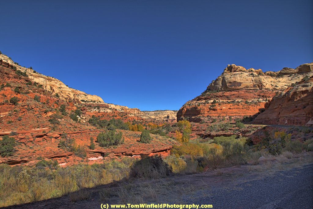
The first 10+ miles of rt 128 is nothing to write home about. and you will wonder "Why so much traffic on this road"? This is the scenic route into Moab. Once the road follows the Colorado River. You will he treated on some beautiful vistas.

As I reached the junction of highway 120 and 191 just North of Moab, it was obvious you saw this is a bicycle town. A beautiful Mid-October day and bicycle riders were out in full force.

My first stop in Moab was the Visitor's Center. Got some information, directions, and reading material. Next was my lodging - The Virginian Motel. Checking in there and unloaded some of the stuff from the car.

The Viginian Motel is an older place. Rooms are roomy enough (places to park my 2 bicycle) and a kitchenette. Yes - even a small stove with oven, but no microwave.

Wanted to get recommendations for singletrack trails to ride. Googled the local Trek Bike dealer. It is Poison Spider Bicycles. Not sure how far, I opted to drive. WRONG! I should had used one of my bicycles! Traffic in town (this was a Saturday afternoon during one of the peak tourist seasons) was terrible. It was much faster (and less aggravation) riding a bike to get where you wanted to go.

Anyway, Eddie and one of the customers (don't you just love bike shops - staff and customers were always ready to help) suggested Intrepid Trails at Dead Horse Point. There, I would find some easy trails, with little climbing, but awesome scenery. Just what I wanted for my Birthday Ride on Monday. I thanked Eddie and promised to be back for some shopping before leaving town.

Back at the motel, I unloaded more for the 4 nights stay in Moab. Soon, it was time to look for some food. This was a "salad day" so was looking for a dull meal, or at least a place that has a salad bar. And, no chain restaurant!

I opted for Pizza. Zax is just 2 blocks from my motel and they offer a pizza, soup, and salad buffet. It the start of dinner time. The place fulled as I was eating. Since I had not eaten (other than a couple snacks) since my hotel breakfast, I was getting hungry! Had my salad. Beer Cheese Soup was one of the offerings - how could I pass THAT. And, of course, beer goes well with pizza. Decided for a pint of Dead Horse Amber Ale brewed locally by The Moab Brewery.

Back at the motel, I transferred photo files form the camera to the laptop. Was getting very tired as I finished up processing my HDR photos (all 93 of them). Crashed into bed.


Friday, October 12, 2012

Long Day on the Road.


Got a early start on my drive - about 1:30. Stopped at Wally-World for a couple things. Was getting close to breakfast time as I neared North Platte.

Since there was a Denny's at the Flying J, I pulled in there. Wanted to do some surfing in the tablet while waiting for my meal. Tried to log in, and was met with "Make an Account". Asked what I need to log in, I was told that they do not have Wi-Fi. There's Wi-Fi at Flying J, but there is a charge. I thought that all Denny's have free Wi-Fi. I registered my complaint. Since I had already ordered food, I was stuck. Had I known, I would have stopped at the Village Inn! Will be writing a letter to the manager to complain. With the problems at the Denny's in Ogalalla (beck in May) it looks like its time to stop eating at Denny's.

Needed to use the rest room as I crossed into Colorado. Checked on when the Information Booth would open - just 10 minutes. Walked back to the car (it was getting too cold and windy to sit outside). I saw some money on the pavement at my car door. Two 5's. Not, I did not have folded 5's in my pocket, i realized it was found money.

It was 43 when I headed out from home. As i climbed toward Denver, the temperature kept dropping. Finally, the sun came up and the temp started climbing. By the time I got to Denver, it was in the mid 60s.

Knew I would likely run into some rain. It started at the Eisenhower Tunnel. Drizzled off and on until I hot Vail Pass. There, I was hit with a deluge. The road was a river. At Eagle, it looked like it might clear off. As I drove down Glenwood Canyon, the clouds got darker.

Except for the rain, it was a beautiful drive down Glenwood Canyon. The Aspen were changing color. Besides I-70, the Colorado River, a railroad track, and bicycle path wind through the canyon. Almost made me want to find a place to park and explore on bicycle.

Got off the interstate and started looking for my hotel. After a couple wrong turns, I found the hotel. The hotel is along the Colorado River. One of Glenwood Springs bicycle trails runs between the river and the hotel (see photo).

Once I got settle in the room, it was time for some food. A friend on fine had suggested the Italian Underground. I did not see beer on their menu and i was in the mood for a local brew and a burger. The Chamber's tourist Trail & Street map (got it from the hotel desk clerk) had an ad for Double Dog Pub. Checked out their web site and opted to head that way.

Eric (a transplanted cyclist) suggested a local brew by Rifle Brewing Company - either an Amber or IPA. I selected the Amber (Anvil Point Amber). Great brew, burger, and kettle chips. BTW - Eric usually rides his nw CX bike to work at the pub.

Would have liked to go downtown to take some photos. But with the rain and being too tired, I just returned to my room. Speaking of the room, I used rewards points for the room (some about to expired this year). They gave me a suite - large room with king bed, fridge, microwave, eating table, desk, and lots of cupboards. View of the Colorado River, though had to settle for a second floor room.

Now that I have checked my mail, scanned fb, and wrote this blog posting - its bed time!

Sunday, October 7, 2012

Bring Your Own Kid Mountain Biking


Saturday was a blustery day for THOR's Bring Your Own Kid Mountain Biking day. This was held in conjunction IMBA's annual function. Temperatures hovered in the 40s with gusty winds from the NW. THOR's party was held in Tranquility Park, Omaha.

The photo is the kids on their bikes and ready to ride some singletrack.

The group headed out for a ride on the Tranquility Park trail. Then it was time for food. Dave, the THOR Grill Master, had grub ready.

After lunch, the kids tested their bike handling abilities with an obstacle course. The adults were ready to help learn techniques and offer some encouragement. The day ending with a pinata filled with candy.

There were plans for "smores" but folks were ready to call it a day, getting out if the cold. All-in-all, a good time was had by all.